You are here: Home > Network List > N4 - Central and EAstern US Network Stations List
> Station W59A Clinton, NC, USA > Earthquake Result Viewer
W59A Clinton, NC, USA - Earthquake Result Viewer
| Earthquake location: |
Komandorskiye Ostrova Region |
| Earthquake latitude/longitude: |
56.2/164.3 |
| Earthquake time(UTC): |
2019/06/25 (176) 09:05:44 GMT |
| Earthquake Depth: |
33 km |
| Earthquake Magnitude: |
6.6 Mi |
| Earthquake Catalog/Contributor: |
NEIC PDE/at |
|
| Network: |
N4 Central and EAstern US Network |
| Station: |
W59A Clinton, NC, USA |
| Lat/Lon: |
35.17 N/78.44 W |
| Elevation: |
60 m |
|
| Distance: |
74.6 deg |
| Az: |
49.068 deg |
| Baz: |
328.979 deg |
| Ray Param: |
0.052185435 |
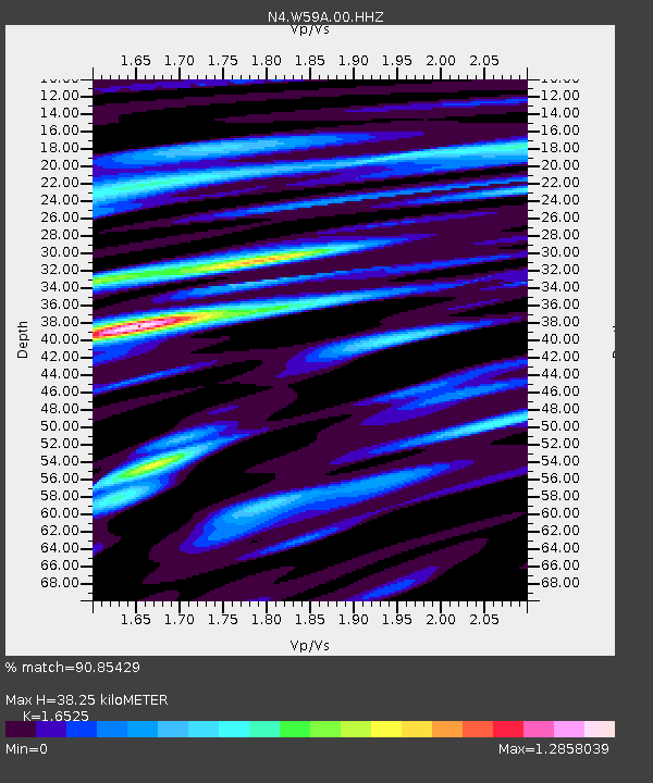
| Estimated Moho Depth: |
38.25 km |
| Estimated Crust Vp/Vs: |
1.65 |
| Assumed Crust Vp: |
6.565 km/s |
| Estimated Crust Vs: |
3.972 km/s |
| Estimated Crust Poisson's Ratio: |
0.21 |
|
| Radial Match: |
90.85429 % |
| Radial Bump: |
400 |
| Transverse Match: |
72.99473 % |
| Transverse Bump: |
400 |
| SOD ConfigId: |
18369291 |
| Insert Time: |
2019-07-09 09:11:33.365 +0000 |
| GWidth: |
2.5 |
| Max Bumps: |
400 |
| Tol: |
0.001 |
|

Signal To Noise
| Channel | StoN | STA | LTA |
| N4:W59A:00:HHZ:20190625T09:16:48.690002Z | 2.2846644 | 3.6133193E-7 | 1.5815536E-7 |
| N4:W59A:00:HH1:20190625T09:16:48.690002Z | 2.245725 | 3.0683128E-7 | 1.3662907E-7 |
| N4:W59A:00:HH2:20190625T09:16:48.690002Z | 1.3016303 | 2.2761542E-7 | 1.7486948E-7 |
| Arrivals |
| Ps | 3.9 SECOND |
| PpPs | 15 SECOND |
| PsPs/PpSs | 19 SECOND |


