You are here: Home > Network List > TA - USArray Transportable Network (new EarthScope stations) Stations List
> Station M31M Drury Creek, Yukon, CA > Earthquake Result Viewer
M31M Drury Creek, Yukon, CA - Earthquake Result Viewer
| Earthquake location: |
Komandorskiye Ostrova Region |
| Earthquake latitude/longitude: |
56.2/164.3 |
| Earthquake time(UTC): |
2019/06/25 (176) 09:05:44 GMT |
| Earthquake Depth: |
33 km |
| Earthquake Magnitude: |
6.6 Mi |
| Earthquake Catalog/Contributor: |
NEIC PDE/at |
|
| Network: |
TA USArray Transportable Network (new EarthScope stations) |
| Station: |
M31M Drury Creek, Yukon, CA |
| Lat/Lon: |
62.20 N/134.39 W |
| Elevation: |
639 m |
|
| Distance: |
30.9 deg |
| Az: |
53.256 deg |
| Baz: |
287.2 deg |
| Ray Param: |
0.07918556 |
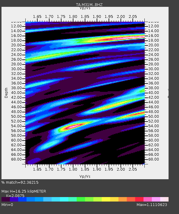
| Estimated Moho Depth: |
16.25 km |
| Estimated Crust Vp/Vs: |
2.09 |
| Assumed Crust Vp: |
6.419 km/s |
| Estimated Crust Vs: |
3.075 km/s |
| Estimated Crust Poisson's Ratio: |
0.35 |
|
| Radial Match: |
92.36215 % |
| Radial Bump: |
369 |
| Transverse Match: |
75.77417 % |
| Transverse Bump: |
400 |
| SOD ConfigId: |
18369291 |
| Insert Time: |
2019-07-09 09:14:02.876 +0000 |
| GWidth: |
2.5 |
| Max Bumps: |
400 |
| Tol: |
0.001 |
|

Signal To Noise
| Channel | StoN | STA | LTA |
| TA:M31M: :BHZ:20190625T09:11:27.049988Z | 3.8872998 | 3.988294E-7 | 1.0259806E-7 |
| TA:M31M: :BHN:20190625T09:11:27.049988Z | 1.6525297 | 1.2949043E-7 | 7.8358916E-8 |
| TA:M31M: :BHE:20190625T09:11:27.049988Z | 3.5040686 | 2.408754E-7 | 6.874163E-8 |
| Arrivals |
| Ps | 2.9 SECOND |
| PpPs | 7.3 SECOND |
| PsPs/PpSs | 10 SECOND |


