You are here: Home > Network List > TA - USArray Transportable Network (new EarthScope stations) Stations List
> Station Q32M Nakina River, BC, CAN > Earthquake Result Viewer
Q32M Nakina River, BC, CAN - Earthquake Result Viewer
| Earthquake location: |
Komandorskiye Ostrova Region |
| Earthquake latitude/longitude: |
56.2/164.3 |
| Earthquake time(UTC): |
2019/06/25 (176) 09:05:44 GMT |
| Earthquake Depth: |
33 km |
| Earthquake Magnitude: |
6.6 Mi |
| Earthquake Catalog/Contributor: |
NEIC PDE/at |
|
| Network: |
TA USArray Transportable Network (new EarthScope stations) |
| Station: |
Q32M Nakina River, BC, CAN |
| Lat/Lon: |
58.96 N/132.27 W |
| Elevation: |
1951 m |
|
| Distance: |
33.0 deg |
| Az: |
58.339 deg |
| Baz: |
293.361 deg |
| Ray Param: |
0.07836085 |
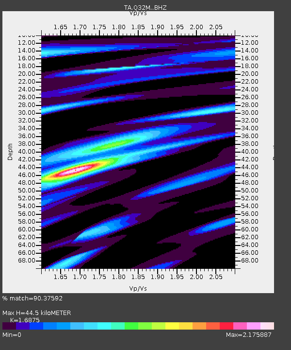
| Estimated Moho Depth: |
44.5 km |
| Estimated Crust Vp/Vs: |
1.69 |
| Assumed Crust Vp: |
6.597 km/s |
| Estimated Crust Vs: |
3.91 km/s |
| Estimated Crust Poisson's Ratio: |
0.23 |
|
| Radial Match: |
90.37592 % |
| Radial Bump: |
400 |
| Transverse Match: |
79.84247 % |
| Transverse Bump: |
400 |
| SOD ConfigId: |
18369291 |
| Insert Time: |
2019-07-09 09:14:07.749 +0000 |
| GWidth: |
2.5 |
| Max Bumps: |
400 |
| Tol: |
0.001 |
|

Signal To Noise
| Channel | StoN | STA | LTA |
| TA:Q32M: :BHZ:20190625T09:11:45.549988Z | 4.4603252 | 3.784185E-7 | 8.4841005E-8 |
| TA:Q32M: :BHN:20190625T09:11:45.549988Z | 1.2113388 | 1.0519187E-7 | 8.683935E-8 |
| TA:Q32M: :BHE:20190625T09:11:45.549988Z | 3.4194856 | 2.6166E-7 | 7.652029E-8 |
| Arrivals |
| Ps | 5.1 SECOND |
| PpPs | 17 SECOND |
| PsPs/PpSs | 22 SECOND |


