You are here: Home > Network List > TA - USArray Transportable Network (new EarthScope stations) Stations List
> Station B17A L&G Farms, Chester, MT, USA > Earthquake Result Viewer
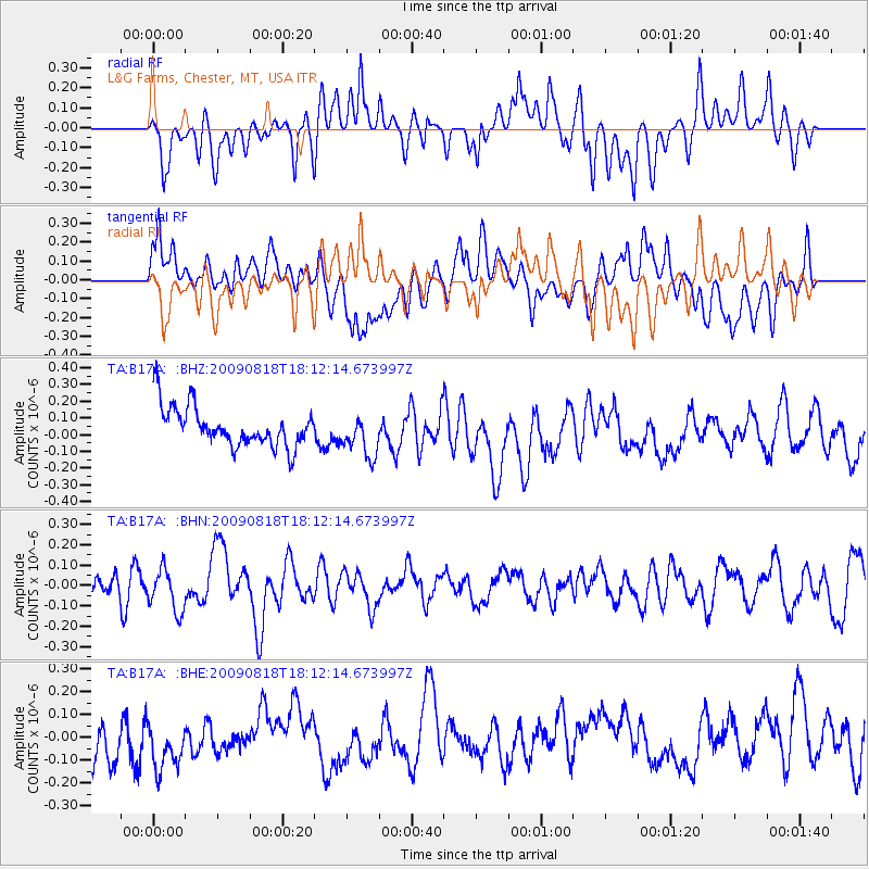
B17A L&G Farms, Chester, MT, USA - Earthquake Result Viewer
*The percent match for this event was below the threshold and hence no stack was calculated.
| Earthquake location: |
Solomon Islands |
| Earthquake latitude/longitude: |
-6.6/154.6 |
| Earthquake time(UTC): |
2009/08/18 (230) 17:59:13 GMT |
| Earthquake Depth: |
35 km |
| Earthquake Magnitude: |
5.6 MW, 5.4 MS, 5.3 MB, 5.6 MW |
| Earthquake Catalog/Contributor: |
WHDF/NEIC |
|
| Network: |
TA USArray Transportable Network (new EarthScope stations) |
| Station: |
B17A L&G Farms, Chester, MT, USA |
| Lat/Lon: |
48.29 N/110.80 W |
| Elevation: |
894 m |
|
| Distance: |
98.0 deg |
| Az: |
42.234 deg |
| Baz: |
269.022 deg |
| Ray Param: |
$rayparam |
*The percent match for this event was below the threshold and hence was not used in the summary stack. |
|
| Radial Match: |
39.93616 % |
| Radial Bump: |
400 |
| Transverse Match: |
42.933613 % |
| Transverse Bump: |
400 |
| SOD ConfigId: |
2622 |
| Insert Time: |
2010-03-07 00:40:43.260 +0000 |
| GWidth: |
2.5 |
| Max Bumps: |
400 |
| Tol: |
0.001 |
|
Signal To Noise
| Channel | StoN | STA | LTA |
| TA:B17A: :BHN:20090818T18:12:14.673997Z | 1.4389764 | 1.04532475E-7 | 7.264363E-8 |
| TA:B17A: :BHE:20090818T18:12:14.673997Z | 1.0771667 | 1.2900772E-7 | 1.1976579E-7 |
| TA:B17A: :BHZ:20090818T18:12:14.673997Z | 1.0655055 | 1.2616098E-7 | 1.18404806E-7 |
| Arrivals |
| Ps | |
| PpPs | |
| PsPs/PpSs | |


