You are here: Home > Network List > CC - Cascade Chain Volcano Monitoring Stations List
> Station PR02 Puyallup River 02 > Earthquake Result Viewer
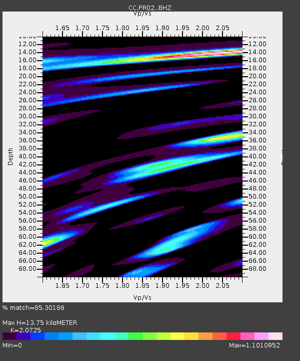
PR02 Puyallup River 02 - Earthquake Result Viewer
| Earthquake location: |
Komandorskiye Ostrova Region |
| Earthquake latitude/longitude: |
56.2/164.1 |
| Earthquake time(UTC): |
2019/06/26 (177) 02:18:07 GMT |
| Earthquake Depth: |
10 km |
| Earthquake Magnitude: |
6.4 Mww |
| Earthquake Catalog/Contributor: |
NEIC PDE/us |
|
| Network: |
CC Cascade Chain Volcano Monitoring |
| Station: |
PR02 Puyallup River 02 |
| Lat/Lon: |
46.92 N/122.05 W |
| Elevation: |
461 m |
|
| Distance: |
44.7 deg |
| Az: |
69.315 deg |
| Baz: |
310.282 deg |
| Ray Param: |
0.07174074 |
| Estimated Moho Depth: |
13.75 km |
| Estimated Crust Vp/Vs: |
2.07 |
| Assumed Crust Vp: |
6.566 km/s |
| Estimated Crust Vs: |
3.168 km/s |
| Estimated Crust Poisson's Ratio: |
0.35 |
|
| Radial Match: |
85.30186 % |
| Radial Bump: |
400 |
| Transverse Match: |
73.1681 % |
| Transverse Bump: |
400 |
| SOD ConfigId: |
18369291 |
| Insert Time: |
2019-07-10 02:20:18.044 +0000 |
| GWidth: |
2.5 |
| Max Bumps: |
400 |
| Tol: |
0.001 |
|

Signal To Noise
| Channel | StoN | STA | LTA |
| CC:PR02: :BHZ:20190626T02:25:50.299988Z | 15.330756 | 1.324845E-6 | 8.6417465E-8 |
| CC:PR02: :BHN:20190626T02:25:50.299988Z | 4.9149337 | 4.9071184E-7 | 9.984099E-8 |
| CC:PR02: :BHE:20190626T02:25:50.299988Z | 4.6510067 | 6.048428E-7 | 1.3004556E-7 |
| Arrivals |
| Ps | 2.4 SECOND |
| PpPs | 6.1 SECOND |
| PsPs/PpSs | 8.5 SECOND |


