You are here: Home > Network List > TA - USArray Transportable Network (new EarthScope stations) Stations List
> Station B17A L&G Farms, Chester, MT, USA > Earthquake Result Viewer
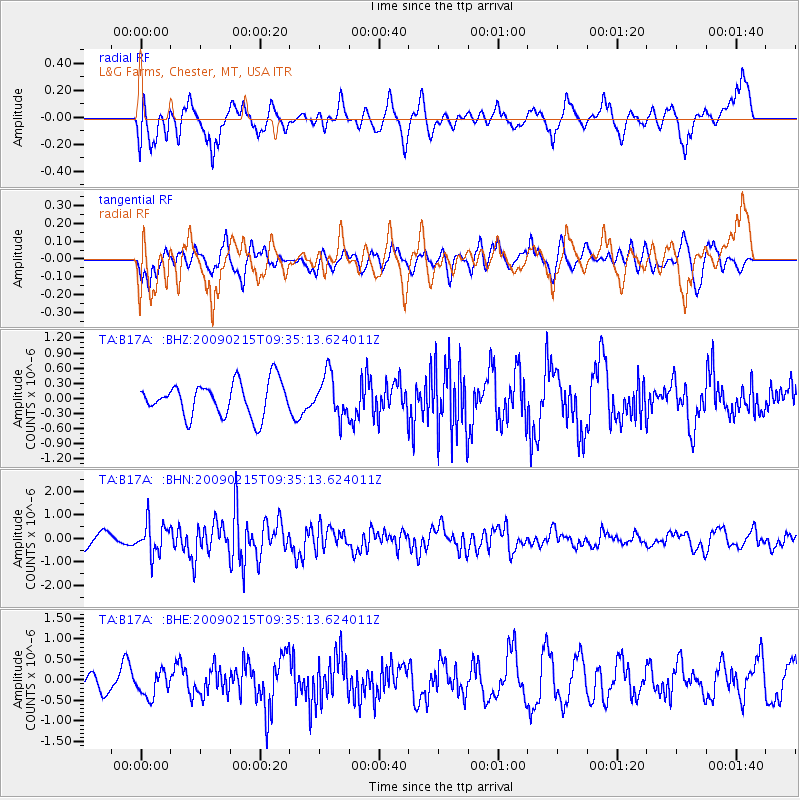
B17A L&G Farms, Chester, MT, USA - Earthquake Result Viewer
*The percent match for this event was below the threshold and hence no stack was calculated.
| Earthquake location: |
Near East Coast Of Honshu, Japan |
| Earthquake latitude/longitude: |
40.2/142.2 |
| Earthquake time(UTC): |
2009/02/15 (046) 09:24:31 GMT |
| Earthquake Depth: |
33 km |
| Earthquake Magnitude: |
6.1 MB, 5.5 MS, 5.7 MW, 5.7 MW |
| Earthquake Catalog/Contributor: |
WHDF/NEIC |
|
| Network: |
TA USArray Transportable Network (new EarthScope stations) |
| Station: |
B17A L&G Farms, Chester, MT, USA |
| Lat/Lon: |
48.29 N/110.80 W |
| Elevation: |
894 m |
|
| Distance: |
70.7 deg |
| Az: |
42.579 deg |
| Baz: |
309.144 deg |
| Ray Param: |
$rayparam |
*The percent match for this event was below the threshold and hence was not used in the summary stack. |
|
| Radial Match: |
69.92765 % |
| Radial Bump: |
400 |
| Transverse Match: |
39.165035 % |
| Transverse Bump: |
365 |
| SOD ConfigId: |
2658 |
| Insert Time: |
2010-03-07 00:41:47.309 +0000 |
| GWidth: |
2.5 |
| Max Bumps: |
400 |
| Tol: |
0.001 |
|
Signal To Noise
| Channel | StoN | STA | LTA |
| TA:B17A: :BHN:20090215T09:35:13.624011Z | 3.2537317 | 6.589001E-7 | 2.0250597E-7 |
| TA:B17A: :BHE:20090215T09:35:13.624011Z | 1.0488552 | 3.048973E-7 | 2.906953E-7 |
| TA:B17A: :BHZ:20090215T09:35:13.624011Z | 1.2474716 | 4.1321132E-7 | 3.3123908E-7 |
| Arrivals |
| Ps | |
| PpPs | |
| PsPs/PpSs | |


