You are here: Home > Network List > EI - Irish National Seismic Network (INSN) Stations List
> Station IDGL INCH ISLAND, CO DONEGAL, IRELAND > Earthquake Result Viewer
IDGL INCH ISLAND, CO DONEGAL, IRELAND - Earthquake Result Viewer
| Earthquake location: |
Komandorskiye Ostrova Region |
| Earthquake latitude/longitude: |
56.2/164.1 |
| Earthquake time(UTC): |
2019/06/26 (177) 02:18:07 GMT |
| Earthquake Depth: |
10 km |
| Earthquake Magnitude: |
6.4 Mww |
| Earthquake Catalog/Contributor: |
NEIC PDE/us |
|
| Network: |
EI Irish National Seismic Network (INSN) |
| Station: |
IDGL INCH ISLAND, CO DONEGAL, IRELAND |
| Lat/Lon: |
55.07 N/7.51 W |
| Elevation: |
123 m |
|
| Distance: |
68.9 deg |
| Az: |
354.86 deg |
| Baz: |
4.996 deg |
| Ray Param: |
0.056012798 |
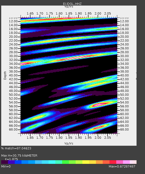
| Estimated Moho Depth: |
30.75 km |
| Estimated Crust Vp/Vs: |
1.88 |
| Assumed Crust Vp: |
6.276 km/s |
| Estimated Crust Vs: |
3.347 km/s |
| Estimated Crust Poisson's Ratio: |
0.30 |
|
| Radial Match: |
87.04623 % |
| Radial Bump: |
353 |
| Transverse Match: |
78.65351 % |
| Transverse Bump: |
400 |
| SOD ConfigId: |
18369291 |
| Insert Time: |
2019-07-10 02:22:43.510 +0000 |
| GWidth: |
2.5 |
| Max Bumps: |
400 |
| Tol: |
0.001 |
|

Signal To Noise
| Channel | StoN | STA | LTA |
| EI:IDGL: :HHZ:20190626T02:28:41.490021Z | 7.132605 | 1.6898194E-6 | 2.3691477E-7 |
| EI:IDGL: :HHN:20190626T02:28:41.490021Z | 2.874767 | 6.5419556E-7 | 2.2756473E-7 |
| EI:IDGL: :HHE:20190626T02:28:41.490021Z | 0.94677514 | 1.8599351E-7 | 1.9644952E-7 |
| Arrivals |
| Ps | 4.4 SECOND |
| PpPs | 14 SECOND |
| PsPs/PpSs | 18 SECOND |


