You are here: Home > Network List > TA - USArray Transportable Network (new EarthScope stations) Stations List
> Station C20A Veseth Ranch, Zortman, MT, USA > Earthquake Result Viewer
C20A Veseth Ranch, Zortman, MT, USA - Earthquake Result Viewer
| Earthquake location: |
Off Coast Of Jalisco, Mexico |
| Earthquake latitude/longitude: |
17.6/-105.5 |
| Earthquake time(UTC): |
2008/09/24 (268) 02:33:05 GMT |
| Earthquake Depth: |
10 km |
| Earthquake Magnitude: |
5.7 MB, 6.2 MS, 6.4 MW, 6.4 MW |
| Earthquake Catalog/Contributor: |
WHDF/NEIC |
|
| Network: |
TA USArray Transportable Network (new EarthScope stations) |
| Station: |
C20A Veseth Ranch, Zortman, MT, USA |
| Lat/Lon: |
47.71 N/108.00 W |
| Elevation: |
781 m |
|
| Distance: |
30.1 deg |
| Az: |
356.627 deg |
| Baz: |
175.233 deg |
| Ray Param: |
0.079422 |
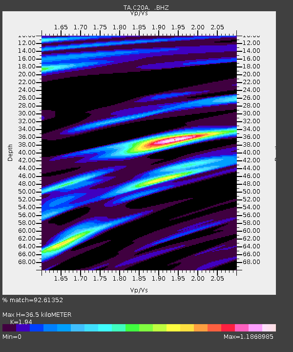
| Estimated Moho Depth: |
36.5 km |
| Estimated Crust Vp/Vs: |
1.94 |
| Assumed Crust Vp: |
6.518 km/s |
| Estimated Crust Vs: |
3.36 km/s |
| Estimated Crust Poisson's Ratio: |
0.32 |
|
| Radial Match: |
92.61352 % |
| Radial Bump: |
289 |
| Transverse Match: |
64.467285 % |
| Transverse Bump: |
362 |
| SOD ConfigId: |
2560 |
| Insert Time: |
2010-03-07 00:42:11.177 +0000 |
| GWidth: |
2.5 |
| Max Bumps: |
400 |
| Tol: |
0.001 |
|

Signal To Noise
| Channel | StoN | STA | LTA |
| TA:C20A: :BHZ:20080924T02:38:44.123992Z | 29.928843 | 2.6352886E-6 | 8.8051806E-8 |
| TA:C20A: :BHN:20080924T02:38:44.123992Z | 12.89143 | 1.930051E-6 | 1.4971583E-7 |
| TA:C20A: :BHE:20080924T02:38:44.123992Z | 3.0753376 | 2.6766577E-7 | 8.703623E-8 |
| Arrivals |
| Ps | 5.7 SECOND |
| PpPs | 15 SECOND |
| PsPs/PpSs | 21 SECOND |


