You are here: Home > Network List > TA - USArray Transportable Network (new EarthScope stations) Stations List
> Station C20A Veseth Ranch, Zortman, MT, USA > Earthquake Result Viewer
C20A Veseth Ranch, Zortman, MT, USA - Earthquake Result Viewer
| Earthquake location: |
Near S. Coast Of Honshu, Japan |
| Earthquake latitude/longitude: |
33.2/137.9 |
| Earthquake time(UTC): |
2009/08/09 (221) 10:55:55 GMT |
| Earthquake Depth: |
297 km |
| Earthquake Magnitude: |
6.5 MB, 7.1 MW, 7.1 MW |
| Earthquake Catalog/Contributor: |
WHDF/NEIC |
|
| Network: |
TA USArray Transportable Network (new EarthScope stations) |
| Station: |
C20A Veseth Ranch, Zortman, MT, USA |
| Lat/Lon: |
47.71 N/108.00 W |
| Elevation: |
781 m |
|
| Distance: |
80.2 deg |
| Az: |
38.745 deg |
| Baz: |
308.984 deg |
| Ray Param: |
0.047678486 |
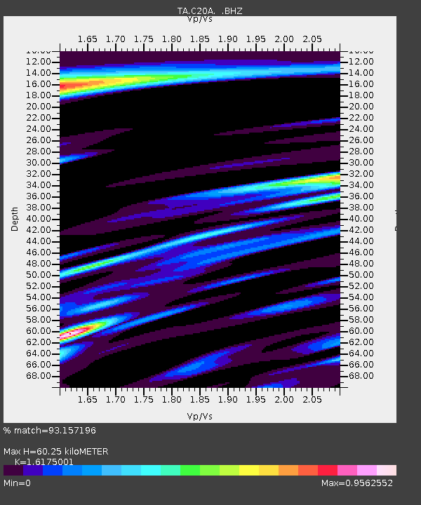
| Estimated Moho Depth: |
60.25 km |
| Estimated Crust Vp/Vs: |
1.62 |
| Assumed Crust Vp: |
6.518 km/s |
| Estimated Crust Vs: |
4.03 km/s |
| Estimated Crust Poisson's Ratio: |
0.19 |
|
| Radial Match: |
93.157196 % |
| Radial Bump: |
400 |
| Transverse Match: |
82.584236 % |
| Transverse Bump: |
400 |
| SOD ConfigId: |
2622 |
| Insert Time: |
2010-03-07 00:42:13.175 +0000 |
| GWidth: |
2.5 |
| Max Bumps: |
400 |
| Tol: |
0.001 |
|

Signal To Noise
| Channel | StoN | STA | LTA |
| TA:C20A: :BHZ:20090809T11:07:02.024001Z | 121.75402 | 1.2962124E-5 | 1.0646156E-7 |
| TA:C20A: :BHN:20090809T11:07:02.024001Z | 42.493393 | 3.343411E-6 | 7.868072E-8 |
| TA:C20A: :BHE:20090809T11:07:02.024001Z | 23.720028 | 2.9499272E-6 | 1.243644E-7 |
| Arrivals |
| Ps | 5.9 SECOND |
| PpPs | 23 SECOND |
| PsPs/PpSs | 29 SECOND |


