You are here: Home > Network List > TA - USArray Transportable Network (new EarthScope stations) Stations List
> Station C20A Veseth Ranch, Zortman, MT, USA > Earthquake Result Viewer
C20A Veseth Ranch, Zortman, MT, USA - Earthquake Result Viewer
| Earthquake location: |
Fox Islands, Aleutian Islands |
| Earthquake latitude/longitude: |
52.8/-167.0 |
| Earthquake time(UTC): |
2009/10/13 (286) 05:37:23 GMT |
| Earthquake Depth: |
24 km |
| Earthquake Magnitude: |
6.0 MB, 6.1 MS, 6.5 MW, 6.5 MW |
| Earthquake Catalog/Contributor: |
WHDF/NEIC |
|
| Network: |
TA USArray Transportable Network (new EarthScope stations) |
| Station: |
C20A Veseth Ranch, Zortman, MT, USA |
| Lat/Lon: |
47.71 N/108.00 W |
| Elevation: |
781 m |
|
| Distance: |
37.1 deg |
| Az: |
73.447 deg |
| Baz: |
300.373 deg |
| Ray Param: |
0.07625985 |
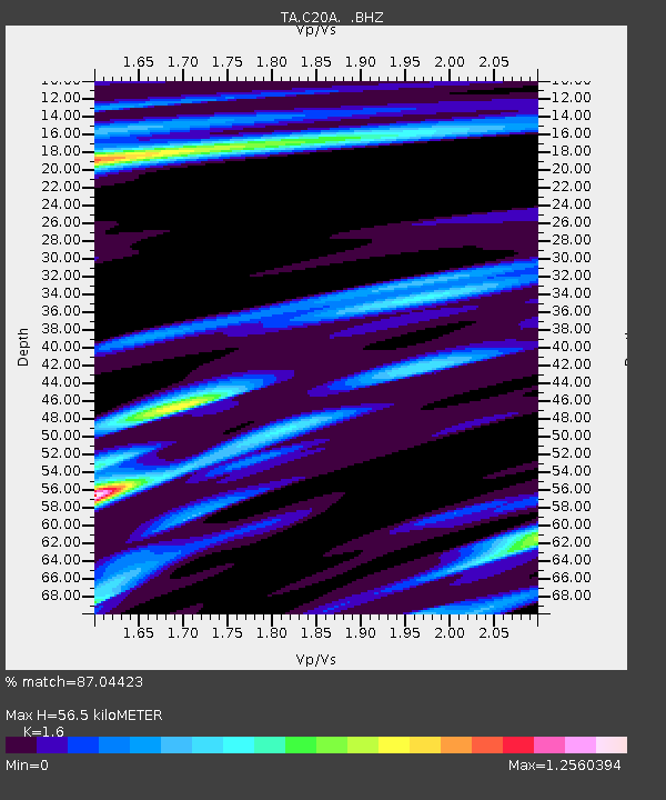
| Estimated Moho Depth: |
56.5 km |
| Estimated Crust Vp/Vs: |
1.60 |
| Assumed Crust Vp: |
6.518 km/s |
| Estimated Crust Vs: |
4.074 km/s |
| Estimated Crust Poisson's Ratio: |
0.18 |
|
| Radial Match: |
87.04423 % |
| Radial Bump: |
356 |
| Transverse Match: |
64.823296 % |
| Transverse Bump: |
400 |
| SOD ConfigId: |
2622 |
| Insert Time: |
2010-03-07 00:42:32.991 +0000 |
| GWidth: |
2.5 |
| Max Bumps: |
400 |
| Tol: |
0.001 |
|

Signal To Noise
| Channel | StoN | STA | LTA |
| TA:C20A: :BHZ:20091013T05:44:01.799009Z | 3.7398689 | 9.0717765E-7 | 2.4256937E-7 |
| TA:C20A: :BHN:20091013T05:44:01.799009Z | 0.4646739 | 2.991188E-7 | 6.4371767E-7 |
| TA:C20A: :BHE:20091013T05:44:01.799009Z | 0.6613969 | 2.7805052E-7 | 4.2039886E-7 |
| Arrivals |
| Ps | 5.7 SECOND |
| PpPs | 21 SECOND |
| PsPs/PpSs | 26 SECOND |


