You are here: Home > Network List > IU - Global Seismograph Network (GSN - IRIS/USGS) Stations List
> Station SLBS Sierra la Laguna Baja California Sur, Mexico > Earthquake Result Viewer
SLBS Sierra la Laguna Baja California Sur, Mexico - Earthquake Result Viewer

| Earthquake location: |
Komandorskiye Ostrova Region |
| Earthquake latitude/longitude: |
56.2/164.1 |
| Earthquake time(UTC): |
2019/06/26 (177) 02:18:07 GMT |
| Earthquake Depth: |
10 km |
| Earthquake Magnitude: |
6.4 Mww |
| Earthquake Catalog/Contributor: |
NEIC PDE/us |
|
| Network: |
IU Global Seismograph Network (GSN - IRIS/USGS) |
| Station: |
SLBS Sierra la Laguna Baja California Sur, Mexico |
| Lat/Lon: |
23.69 N/109.94 W |
| Elevation: |
825 m |
|
| Distance: |
68.4 deg |
| Az: |
79.515 deg |
| Baz: |
323.162 deg |
| Ray Param: |
0.05631048 |
| Estimated Moho Depth: |
12.75 km |
| Estimated Crust Vp/Vs: |
1.79 |
| Assumed Crust Vp: |
6.183 km/s |
| Estimated Crust Vs: |
3.454 km/s |
| Estimated Crust Poisson's Ratio: |
0.27 |
|
| Radial Match: |
86.95889 % |
| Radial Bump: |
400 |
| Transverse Match: |
78.74501 % |
| Transverse Bump: |
400 |
| SOD ConfigId: |
18369291 |
| Insert Time: |
2019-07-10 02:24:08.390 +0000 |
| GWidth: |
2.5 |
| Max Bumps: |
400 |
| Tol: |
0.001 |
|
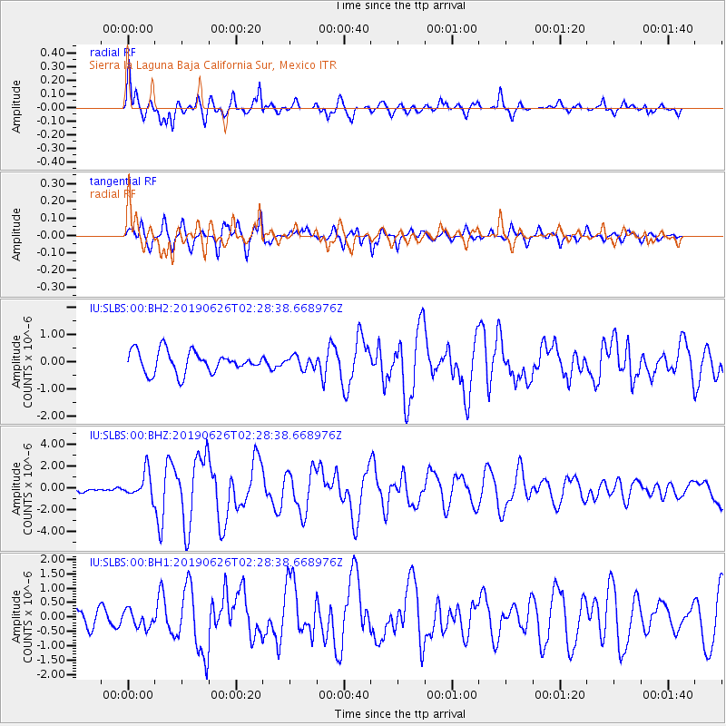
Signal To Noise
| Channel | StoN | STA | LTA |
| IU:SLBS:00:BHZ:20190626T02:28:38.668976Z | 3.2903147 | 1.1958708E-6 | 3.6345182E-7 |
| IU:SLBS:00:BH1:20190626T02:28:38.668976Z | 1.5473201 | 2.9700914E-7 | 1.9195066E-7 |
| IU:SLBS:00:BH2:20190626T02:28:38.668976Z | 0.58049554 | 2.2692218E-7 | 3.9091117E-7 |
| Arrivals |
| Ps | 1.7 SECOND |
| PpPs | 5.6 SECOND |
| PsPs/PpSs | 7.2 SECOND |


