You are here: Home > Network List > MX - Mexican National Seismic Network Stations List
> Station MOIG Morelia, Mich, MX > Earthquake Result Viewer
MOIG Morelia, Mich, MX - Earthquake Result Viewer
| Earthquake location: |
Komandorskiye Ostrova Region |
| Earthquake latitude/longitude: |
56.2/164.1 |
| Earthquake time(UTC): |
2019/06/26 (177) 02:18:07 GMT |
| Earthquake Depth: |
10 km |
| Earthquake Magnitude: |
6.4 Mww |
| Earthquake Catalog/Contributor: |
NEIC PDE/us |
|
| Network: |
MX Mexican National Seismic Network |
| Station: |
MOIG Morelia, Mich, MX |
| Lat/Lon: |
19.65 N/101.23 W |
| Elevation: |
2000 m |
|
| Distance: |
76.4 deg |
| Az: |
75.096 deg |
| Baz: |
325.032 deg |
| Ray Param: |
0.050995383 |
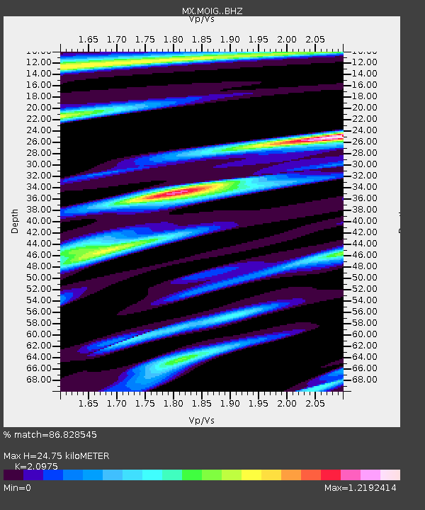
| Estimated Moho Depth: |
24.75 km |
| Estimated Crust Vp/Vs: |
2.10 |
| Assumed Crust Vp: |
6.566 km/s |
| Estimated Crust Vs: |
3.13 km/s |
| Estimated Crust Poisson's Ratio: |
0.35 |
|
| Radial Match: |
86.828545 % |
| Radial Bump: |
400 |
| Transverse Match: |
78.6541 % |
| Transverse Bump: |
400 |
| SOD ConfigId: |
18369291 |
| Insert Time: |
2019-07-10 02:25:16.201 +0000 |
| GWidth: |
2.5 |
| Max Bumps: |
400 |
| Tol: |
0.001 |
|

Signal To Noise
| Channel | StoN | STA | LTA |
| MX:MOIG: :BHZ:20190626T02:29:26.285003Z | 6.3086963 | 1.2701821E-6 | 2.0133828E-7 |
| MX:MOIG: :BHN:20190626T02:29:26.285003Z | 1.759706 | 5.4603714E-7 | 3.103002E-7 |
| MX:MOIG: :BHE:20190626T02:29:26.285003Z | 1.3156053 | 3.4407194E-7 | 2.6153128E-7 |
| Arrivals |
| Ps | 4.3 SECOND |
| PpPs | 11 SECOND |
| PsPs/PpSs | 16 SECOND |


