You are here: Home > Network List > TA - USArray Transportable Network (new EarthScope stations) Stations List
> Station C20A Veseth Ranch, Zortman, MT, USA > Earthquake Result Viewer
C20A Veseth Ranch, Zortman, MT, USA - Earthquake Result Viewer
*The percent match for this event was below the threshold and hence no stack was calculated.
| Earthquake location: |
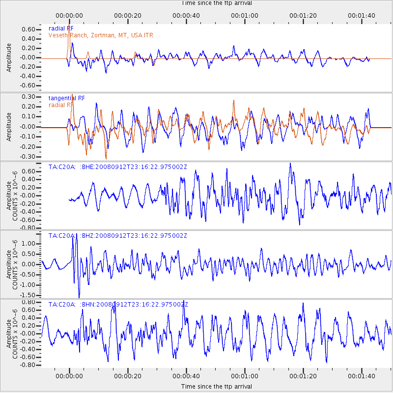
Komandorskiye Ostrova Region |
| Earthquake latitude/longitude: |
56.3/164.1 |
| Earthquake time(UTC): |
2008/09/12 (256) 23:07:50 GMT |
| Earthquake Depth: |
9.3 km |
| Earthquake Magnitude: |
5.5 MB, 5.7 MS, 5.9 MW, 5.9 MW |
| Earthquake Catalog/Contributor: |
WHDF/NEIC |
|
| Network: |
TA USArray Transportable Network (new EarthScope stations) |
| Station: |
C20A Veseth Ranch, Zortman, MT, USA |
| Lat/Lon: |
47.71 N/108.00 W |
| Elevation: |
781 m |
|
| Distance: |
51.2 deg |
| Az: |
59.94 deg |
| Baz: |
314.414 deg |
| Ray Param: |
$rayparam |
*The percent match for this event was below the threshold and hence was not used in the summary stack. |
|
| Radial Match: |
54.08325 % |
| Radial Bump: |
400 |
| Transverse Match: |
63.431057 % |
| Transverse Bump: |
400 |
| SOD ConfigId: |
2560 |
| Insert Time: |
2010-03-07 00:43:25.249 +0000 |
| GWidth: |
2.5 |
| Max Bumps: |
400 |
| Tol: |
0.001 |
|
Signal To Noise
| Channel | StoN | STA | LTA |
| TA:C20A: :BHZ:20080912T23:16:22.975002Z | 5.050103 | 7.284803E-7 | 1.4425058E-7 |
| TA:C20A: :BHN:20080912T23:16:22.975002Z | 0.760677 | 2.456987E-7 | 3.2300002E-7 |
| TA:C20A: :BHE:20080912T23:16:22.975002Z | 1.1620039 | 1.8108194E-7 | 1.5583592E-7 |
| Arrivals |
| Ps | |
| PpPs | |
| PsPs/PpSs | |


