You are here: Home > Network List > N4 - Central and EAstern US Network Stations List
> Station M44A Midewin, Midewin Nat. Tallgrass Prarie, IL, USA > Earthquake Result Viewer
M44A Midewin, Midewin Nat. Tallgrass Prarie, IL, USA - Earthquake Result Viewer
| Earthquake location: |
Komandorskiye Ostrova Region |
| Earthquake latitude/longitude: |
56.2/164.1 |
| Earthquake time(UTC): |
2019/06/26 (177) 02:18:07 GMT |
| Earthquake Depth: |
10 km |
| Earthquake Magnitude: |
6.4 Mww |
| Earthquake Catalog/Contributor: |
NEIC PDE/us |
|
| Network: |
N4 Central and EAstern US Network |
| Station: |
M44A Midewin, Midewin Nat. Tallgrass Prarie, IL, USA |
| Lat/Lon: |
41.39 N/88.04 W |
| Elevation: |
207 m |
|
| Distance: |
65.3 deg |
| Az: |
52.026 deg |
| Baz: |
324.155 deg |
| Ray Param: |
0.058343846 |
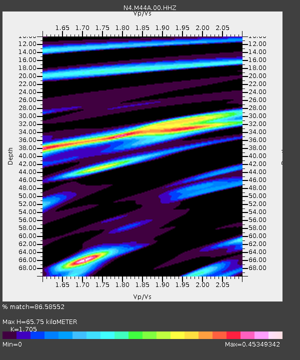
| Estimated Moho Depth: |
65.75 km |
| Estimated Crust Vp/Vs: |
1.71 |
| Assumed Crust Vp: |
6.498 km/s |
| Estimated Crust Vs: |
3.811 km/s |
| Estimated Crust Poisson's Ratio: |
0.24 |
|
| Radial Match: |
86.58552 % |
| Radial Bump: |
278 |
| Transverse Match: |
67.087204 % |
| Transverse Bump: |
400 |
| SOD ConfigId: |
18369291 |
| Insert Time: |
2019-07-10 02:25:50.059 +0000 |
| GWidth: |
2.5 |
| Max Bumps: |
400 |
| Tol: |
0.001 |
|

Signal To Noise
| Channel | StoN | STA | LTA |
| N4:M44A:00:HHZ:20190626T02:28:18.970001Z | 6.820131 | 1.2717439E-6 | 1.8646914E-7 |
| N4:M44A:00:HH1:20190626T02:28:18.970001Z | 3.9851906 | 4.364096E-7 | 1.0950784E-7 |
| N4:M44A:00:HH2:20190626T02:28:18.970001Z | 2.2040248 | 4.0675945E-7 | 1.8455303E-7 |
| Arrivals |
| Ps | 7.5 SECOND |
| PpPs | 26 SECOND |
| PsPs/PpSs | 34 SECOND |


