You are here: Home > Network List > N4 - Central and EAstern US Network Stations List
> Station O48B Farmland, IN, USA > Earthquake Result Viewer
O48B Farmland, IN, USA - Earthquake Result Viewer
| Earthquake location: |
Komandorskiye Ostrova Region |
| Earthquake latitude/longitude: |
56.2/164.1 |
| Earthquake time(UTC): |
2019/06/26 (177) 02:18:07 GMT |
| Earthquake Depth: |
10 km |
| Earthquake Magnitude: |
6.4 Mww |
| Earthquake Catalog/Contributor: |
NEIC PDE/us |
|
| Network: |
N4 Central and EAstern US Network |
| Station: |
O48B Farmland, IN, USA |
| Lat/Lon: |
40.26 N/85.16 W |
| Elevation: |
300 m |
|
| Distance: |
67.5 deg |
| Az: |
50.781 deg |
| Baz: |
325.537 deg |
| Ray Param: |
0.056906894 |
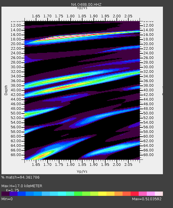
| Estimated Moho Depth: |
17.0 km |
| Estimated Crust Vp/Vs: |
1.75 |
| Assumed Crust Vp: |
6.498 km/s |
| Estimated Crust Vs: |
3.713 km/s |
| Estimated Crust Poisson's Ratio: |
0.26 |
|
| Radial Match: |
94.361786 % |
| Radial Bump: |
311 |
| Transverse Match: |
77.530914 % |
| Transverse Bump: |
400 |
| SOD ConfigId: |
18369291 |
| Insert Time: |
2019-07-10 02:25:58.030 +0000 |
| GWidth: |
2.5 |
| Max Bumps: |
400 |
| Tol: |
0.001 |
|

Signal To Noise
| Channel | StoN | STA | LTA |
| N4:O48B:00:HHZ:20190626T02:28:32.930023Z | 9.740758 | 1.4033568E-6 | 1.440706E-7 |
| N4:O48B:00:HH1:20190626T02:28:32.930023Z | 5.195279 | 6.1954216E-7 | 1.19251E-7 |
| N4:O48B:00:HH2:20190626T02:28:32.930023Z | 7.4932714 | 5.534238E-7 | 7.385609E-8 |
| Arrivals |
| Ps | 2.0 SECOND |
| PpPs | 6.9 SECOND |
| PsPs/PpSs | 9.0 SECOND |


