You are here: Home > Network List > N4 - Central and EAstern US Network Stations List
> Station P48A Milroy, IN, USA > Earthquake Result Viewer
P48A Milroy, IN, USA - Earthquake Result Viewer
| Earthquake location: |
Komandorskiye Ostrova Region |
| Earthquake latitude/longitude: |
56.2/164.1 |
| Earthquake time(UTC): |
2019/06/26 (177) 02:18:07 GMT |
| Earthquake Depth: |
10 km |
| Earthquake Magnitude: |
6.4 Mww |
| Earthquake Catalog/Contributor: |
NEIC PDE/us |
|
| Network: |
N4 Central and EAstern US Network |
| Station: |
P48A Milroy, IN, USA |
| Lat/Lon: |
39.46 N/85.43 W |
| Elevation: |
300 m |
|
| Distance: |
68.1 deg |
| Az: |
51.452 deg |
| Baz: |
325.619 deg |
| Ray Param: |
0.056555808 |
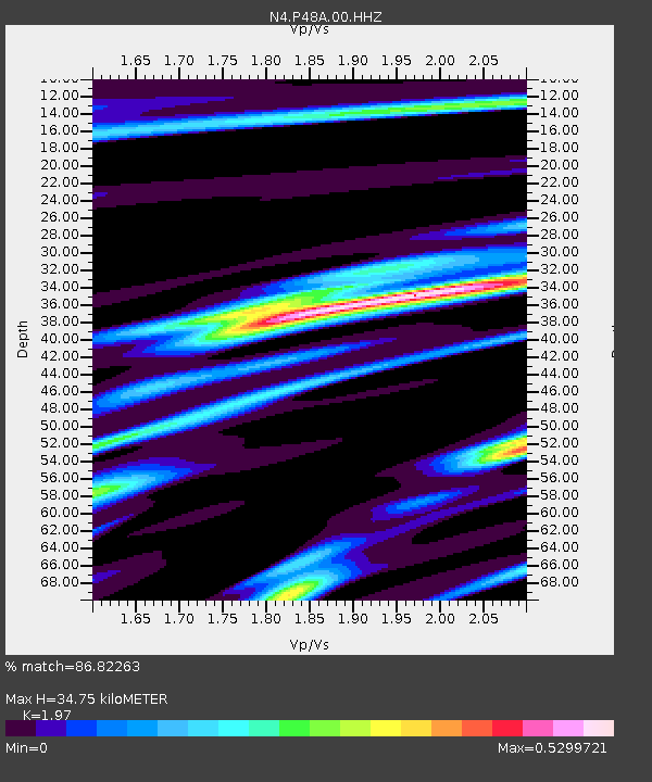
| Estimated Moho Depth: |
34.75 km |
| Estimated Crust Vp/Vs: |
1.97 |
| Assumed Crust Vp: |
6.498 km/s |
| Estimated Crust Vs: |
3.298 km/s |
| Estimated Crust Poisson's Ratio: |
0.33 |
|
| Radial Match: |
86.82263 % |
| Radial Bump: |
291 |
| Transverse Match: |
78.32046 % |
| Transverse Bump: |
400 |
| SOD ConfigId: |
18369291 |
| Insert Time: |
2019-07-10 02:26:01.415 +0000 |
| GWidth: |
2.5 |
| Max Bumps: |
400 |
| Tol: |
0.001 |
|

Signal To Noise
| Channel | StoN | STA | LTA |
| N4:P48A:00:HHZ:20190626T02:28:36.30899Z | 12.068534 | 1.5409275E-6 | 1.2768142E-7 |
| N4:P48A:00:HH1:20190626T02:28:36.30899Z | 4.277973 | 4.948167E-7 | 1.1566615E-7 |
| N4:P48A:00:HH2:20190626T02:28:36.30899Z | 4.7282996 | 5.192931E-7 | 1.0982661E-7 |
| Arrivals |
| Ps | 5.4 SECOND |
| PpPs | 15 SECOND |
| PsPs/PpSs | 21 SECOND |


