You are here: Home > Network List > N4 - Central and EAstern US Network Stations List
> Station T42B T42B > Earthquake Result Viewer
T42B T42B - Earthquake Result Viewer
| Earthquake location: |
Komandorskiye Ostrova Region |
| Earthquake latitude/longitude: |
56.2/164.1 |
| Earthquake time(UTC): |
2019/06/26 (177) 02:18:07 GMT |
| Earthquake Depth: |
10 km |
| Earthquake Magnitude: |
6.4 Mww |
| Earthquake Catalog/Contributor: |
NEIC PDE/us |
|
| Network: |
N4 Central and EAstern US Network |
| Station: |
T42B T42B |
| Lat/Lon: |
37.03 N/91.09 W |
| Elevation: |
165 m |
|
| Distance: |
67.5 deg |
| Az: |
56.902 deg |
| Baz: |
324.187 deg |
| Ray Param: |
0.0569353 |
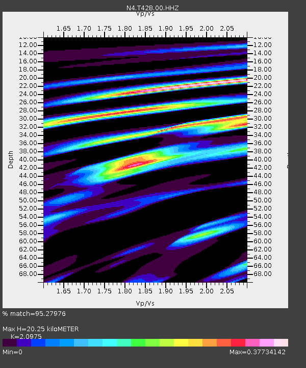
| Estimated Moho Depth: |
20.25 km |
| Estimated Crust Vp/Vs: |
2.10 |
| Assumed Crust Vp: |
6.53 km/s |
| Estimated Crust Vs: |
3.113 km/s |
| Estimated Crust Poisson's Ratio: |
0.35 |
|
| Radial Match: |
95.27976 % |
| Radial Bump: |
231 |
| Transverse Match: |
85.06503 % |
| Transverse Bump: |
400 |
| SOD ConfigId: |
18369291 |
| Insert Time: |
2019-07-10 02:26:13.994 +0000 |
| GWidth: |
2.5 |
| Max Bumps: |
400 |
| Tol: |
0.001 |
|

Signal To Noise
| Channel | StoN | STA | LTA |
| N4:T42B:00:HHZ:20190626T02:28:32.649994Z | 13.64531 | 1.5224505E-6 | 1.11573165E-7 |
| N4:T42B:00:HH1:20190626T02:28:32.649994Z | 10.181046 | 6.7047733E-7 | 6.585545E-8 |
| N4:T42B:00:HH2:20190626T02:28:32.649994Z | 8.047069 | 4.8013436E-7 | 5.9665744E-8 |
| Arrivals |
| Ps | 3.5 SECOND |
| PpPs | 9.3 SECOND |
| PsPs/PpSs | 13 SECOND |


