You are here: Home > Network List > WY - Yellowstone Wyoming Seismic Network Stations List
> Station YMR Madison River, YNP, WY, USA > Earthquake Result Viewer
YMR Madison River, YNP, WY, USA - Earthquake Result Viewer
| Earthquake location: |
Southern Peru |
| Earthquake latitude/longitude: |
-15.3/-70.8 |
| Earthquake time(UTC): |
2016/12/01 (336) 22:40:26 GMT |
| Earthquake Depth: |
10 km |
| Earthquake Magnitude: |
6.3 Mww |
| Earthquake Catalog/Contributor: |
NEIC PDE/us |
|
| Network: |
WY Yellowstone Wyoming Seismic Network |
| Station: |
YMR Madison River, YNP, WY, USA |
| Lat/Lon: |
44.67 N/110.96 W |
| Elevation: |
2149 m |
|
| Distance: |
70.0 deg |
| Az: |
330.686 deg |
| Baz: |
138.542 deg |
| Ray Param: |
0.055287242 |
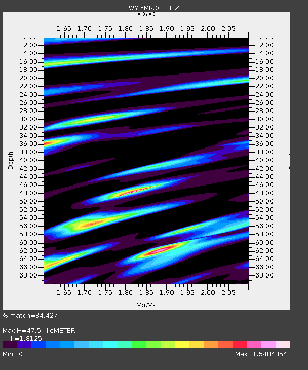
| Estimated Moho Depth: |
47.5 km |
| Estimated Crust Vp/Vs: |
1.81 |
| Assumed Crust Vp: |
6.35 km/s |
| Estimated Crust Vs: |
3.503 km/s |
| Estimated Crust Poisson's Ratio: |
0.28 |
|
| Radial Match: |
84.427 % |
| Radial Bump: |
400 |
| Transverse Match: |
76.43615 % |
| Transverse Bump: |
400 |
| SOD ConfigId: |
1894071 |
| Insert Time: |
2016-12-15 22:49:00.487 +0000 |
| GWidth: |
2.5 |
| Max Bumps: |
400 |
| Tol: |
0.001 |
|

Signal To Noise
| Channel | StoN | STA | LTA |
| WY:YMR:01:HHZ:20161201T22:51:06.527974Z | 4.291377 | 2.1328677E-8 | 4.9701243E-9 |
| WY:YMR:01:HHN:20161201T22:51:06.527974Z | 0.9803197 | 9.47318E-9 | 9.663358E-9 |
| WY:YMR:01:HHE:20161201T22:51:06.527974Z | 1.8598058 | 1.135743E-8 | 6.1067826E-9 |
| Arrivals |
| Ps | 6.3 SECOND |
| PpPs | 20 SECOND |
| PsPs/PpSs | 27 SECOND |


