You are here: Home > Network List > O2 - Oklahoma Consolidated Temporary Seismic Networks Stations List
> Station FW08 Chester, Oklahoma, USA > Earthquake Result Viewer
FW08 Chester, Oklahoma, USA - Earthquake Result Viewer
| Earthquake location: |
Komandorskiye Ostrova Region |
| Earthquake latitude/longitude: |
56.2/164.1 |
| Earthquake time(UTC): |
2019/06/26 (177) 02:18:07 GMT |
| Earthquake Depth: |
10 km |
| Earthquake Magnitude: |
6.4 Mww |
| Earthquake Catalog/Contributor: |
NEIC PDE/us |
|
| Network: |
O2 Oklahoma Consolidated Temporary Seismic Networks |
| Station: |
FW08 Chester, Oklahoma, USA |
| Lat/Lon: |
36.24 N/98.80 W |
| Elevation: |
554 m |
|
| Distance: |
64.4 deg |
| Az: |
62.847 deg |
| Baz: |
322.033 deg |
| Ray Param: |
0.058959376 |
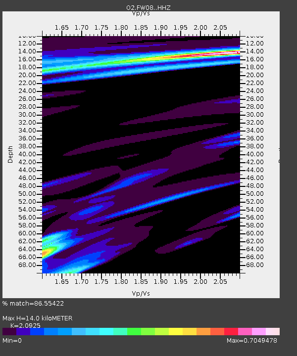
| Estimated Moho Depth: |
14.0 km |
| Estimated Crust Vp/Vs: |
2.09 |
| Assumed Crust Vp: |
6.426 km/s |
| Estimated Crust Vs: |
3.071 km/s |
| Estimated Crust Poisson's Ratio: |
0.35 |
|
| Radial Match: |
86.55422 % |
| Radial Bump: |
400 |
| Transverse Match: |
66.31404 % |
| Transverse Bump: |
400 |
| SOD ConfigId: |
18369291 |
| Insert Time: |
2019-07-10 02:27:28.448 +0000 |
| GWidth: |
2.5 |
| Max Bumps: |
400 |
| Tol: |
0.001 |
|

Signal To Noise
| Channel | StoN | STA | LTA |
| O2:FW08: :HHZ:20190626T02:28:12.800018Z | 4.3210897 | 1.2317474E-6 | 2.8505482E-7 |
| O2:FW08: :HHN:20190626T02:28:12.800018Z | 1.1174979 | 1.1933178E-6 | 1.0678478E-6 |
| O2:FW08: :HHE:20190626T02:28:12.800018Z | 1.5027429 | 6.4105564E-7 | 4.2659036E-7 |
| Arrivals |
| Ps | 2.5 SECOND |
| PpPs | 6.5 SECOND |
| PsPs/PpSs | 9.0 SECOND |


