You are here: Home > Network List > O2 - Oklahoma Consolidated Temporary Seismic Networks Stations List
> Station SC10 Scott, Oklahoma, USA > Earthquake Result Viewer
SC10 Scott, Oklahoma, USA - Earthquake Result Viewer
| Earthquake location: |
Komandorskiye Ostrova Region |
| Earthquake latitude/longitude: |
56.2/164.1 |
| Earthquake time(UTC): |
2019/06/26 (177) 02:18:07 GMT |
| Earthquake Depth: |
10 km |
| Earthquake Magnitude: |
6.4 Mww |
| Earthquake Catalog/Contributor: |
NEIC PDE/us |
|
| Network: |
O2 Oklahoma Consolidated Temporary Seismic Networks |
| Station: |
SC10 Scott, Oklahoma, USA |
| Lat/Lon: |
35.42 N/98.27 W |
| Elevation: |
502 m |
|
| Distance: |
65.3 deg |
| Az: |
63.026 deg |
| Baz: |
322.415 deg |
| Ray Param: |
0.058372967 |
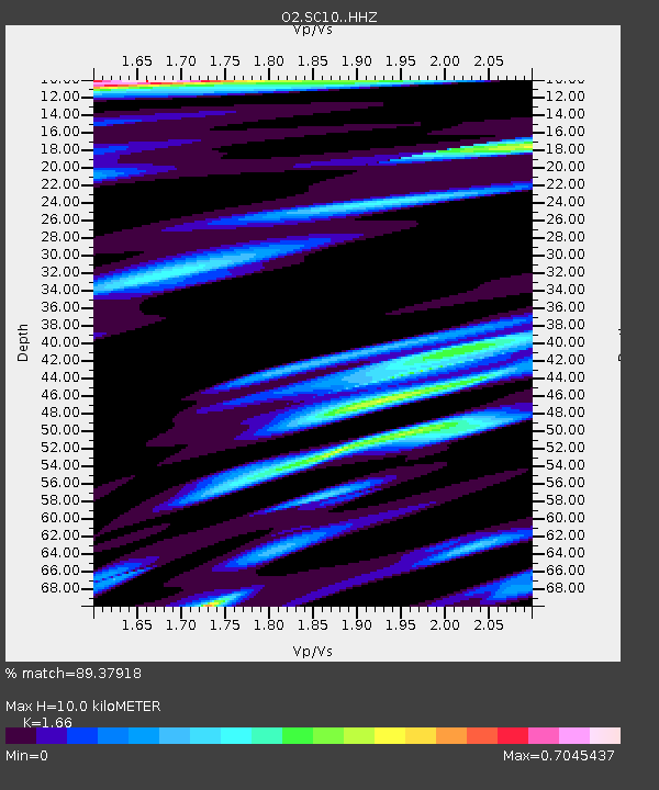
| Estimated Moho Depth: |
10.0 km |
| Estimated Crust Vp/Vs: |
1.66 |
| Assumed Crust Vp: |
6.315 km/s |
| Estimated Crust Vs: |
3.804 km/s |
| Estimated Crust Poisson's Ratio: |
0.22 |
|
| Radial Match: |
89.37918 % |
| Radial Bump: |
400 |
| Transverse Match: |
73.66878 % |
| Transverse Bump: |
400 |
| SOD ConfigId: |
18369291 |
| Insert Time: |
2019-07-10 02:27:36.256 +0000 |
| GWidth: |
2.5 |
| Max Bumps: |
400 |
| Tol: |
0.001 |
|

Signal To Noise
| Channel | StoN | STA | LTA |
| O2:SC10: :HHZ:20190626T02:28:18.680023Z | 5.9628296 | 1.3505505E-6 | 2.2649492E-7 |
| O2:SC10: :HHN:20190626T02:28:18.680023Z | 4.186641 | 6.732948E-7 | 1.608198E-7 |
| O2:SC10: :HHE:20190626T02:28:18.680023Z | 1.6915154 | 4.0520428E-7 | 2.3955104E-7 |
| Arrivals |
| Ps | 1.1 SECOND |
| PpPs | 4.0 SECOND |
| PsPs/PpSs | 5.1 SECOND |


