You are here: Home > Network List > OX - North-East Italy Seismic Network Stations List
> Station CGRP Cima Grappa > Earthquake Result Viewer
CGRP Cima Grappa - Earthquake Result Viewer
| Earthquake location: |
Komandorskiye Ostrova Region |
| Earthquake latitude/longitude: |
56.2/164.1 |
| Earthquake time(UTC): |
2019/06/26 (177) 02:18:07 GMT |
| Earthquake Depth: |
10 km |
| Earthquake Magnitude: |
6.4 Mww |
| Earthquake Catalog/Contributor: |
NEIC PDE/us |
|
| Network: |
OX North-East Italy Seismic Network |
| Station: |
CGRP Cima Grappa |
| Lat/Lon: |
45.88 N/11.80 E |
| Elevation: |
1757 m |
|
| Distance: |
75.7 deg |
| Az: |
340.438 deg |
| Baz: |
15.54 deg |
| Ray Param: |
0.051512513 |
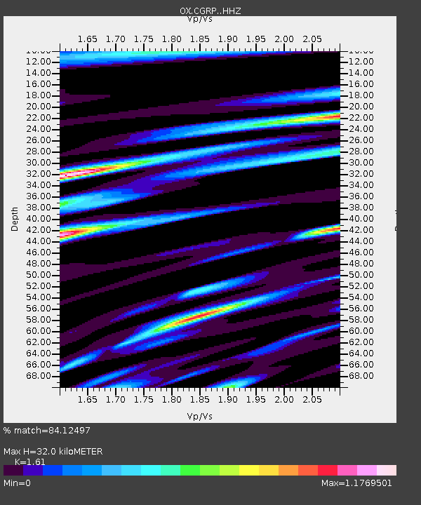
| Estimated Moho Depth: |
32.0 km |
| Estimated Crust Vp/Vs: |
1.61 |
| Assumed Crust Vp: |
6.155 km/s |
| Estimated Crust Vs: |
3.823 km/s |
| Estimated Crust Poisson's Ratio: |
0.19 |
|
| Radial Match: |
84.12497 % |
| Radial Bump: |
400 |
| Transverse Match: |
81.55013 % |
| Transverse Bump: |
400 |
| SOD ConfigId: |
18369291 |
| Insert Time: |
2019-07-10 02:28:05.880 +0000 |
| GWidth: |
2.5 |
| Max Bumps: |
400 |
| Tol: |
0.001 |
|

Signal To Noise
| Channel | StoN | STA | LTA |
| OX:CGRP: :HHZ:20190626T02:29:21.928009Z | 28.625 | 1.4507137E-6 | 5.0679954E-8 |
| OX:CGRP: :HHN:20190626T02:29:21.928009Z | 13.007136 | 5.5162326E-7 | 4.240928E-8 |
| OX:CGRP: :HHE:20190626T02:29:21.928009Z | 5.7229514 | 3.0778654E-7 | 5.3781083E-8 |
| Arrivals |
| Ps | 3.3 SECOND |
| PpPs | 13 SECOND |
| PsPs/PpSs | 16 SECOND |


