You are here: Home > Network List > PE - Penn State Network Stations List
> Station PACW Cowans Gap State Park, Fort Loudon, PA > Earthquake Result Viewer
PACW Cowans Gap State Park, Fort Loudon, PA - Earthquake Result Viewer
| Earthquake location: |
Komandorskiye Ostrova Region |
| Earthquake latitude/longitude: |
56.2/164.1 |
| Earthquake time(UTC): |
2019/06/26 (177) 02:18:07 GMT |
| Earthquake Depth: |
10 km |
| Earthquake Magnitude: |
6.4 Mww |
| Earthquake Catalog/Contributor: |
NEIC PDE/us |
|
| Network: |
PE Penn State Network |
| Station: |
PACW Cowans Gap State Park, Fort Loudon, PA |
| Lat/Lon: |
40.00 N/77.92 W |
| Elevation: |
394 m |
|
| Distance: |
70.8 deg |
| Az: |
45.959 deg |
| Baz: |
328.464 deg |
| Ray Param: |
0.054773554 |
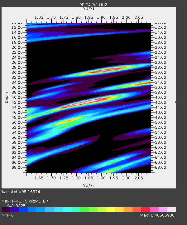
| Estimated Moho Depth: |
41.75 km |
| Estimated Crust Vp/Vs: |
1.83 |
| Assumed Crust Vp: |
6.419 km/s |
| Estimated Crust Vs: |
3.503 km/s |
| Estimated Crust Poisson's Ratio: |
0.29 |
|
| Radial Match: |
95.16974 % |
| Radial Bump: |
263 |
| Transverse Match: |
78.34976 % |
| Transverse Bump: |
374 |
| SOD ConfigId: |
18369291 |
| Insert Time: |
2019-07-10 02:28:12.832 +0000 |
| GWidth: |
2.5 |
| Max Bumps: |
400 |
| Tol: |
0.001 |
|

Signal To Noise
| Channel | StoN | STA | LTA |
| PE:PACW: :HHZ:20190626T02:28:52.980011Z | 18.19577 | 1.9068734E-6 | 1.0479762E-7 |
| PE:PACW: :HHN:20190626T02:28:52.980011Z | 6.9916344 | 6.6765057E-7 | 9.549277E-8 |
| PE:PACW: :HHE:20190626T02:28:52.980011Z | 3.2923083 | 3.7028752E-7 | 1.1247048E-7 |
| Arrivals |
| Ps | 5.6 SECOND |
| PpPs | 18 SECOND |
| PsPs/PpSs | 23 SECOND |


