You are here: Home > Network List > PL - Polish Seismological Network Stations List
> Station BEL PLSN Station Belsk, Poland > Earthquake Result Viewer
BEL PLSN Station Belsk, Poland - Earthquake Result Viewer
| Earthquake location: |
Komandorskiye Ostrova Region |
| Earthquake latitude/longitude: |
56.2/164.1 |
| Earthquake time(UTC): |
2019/06/26 (177) 02:18:07 GMT |
| Earthquake Depth: |
10 km |
| Earthquake Magnitude: |
6.4 Mww |
| Earthquake Catalog/Contributor: |
NEIC PDE/us |
|
| Network: |
PL Polish Seismological Network |
| Station: |
BEL PLSN Station Belsk, Poland |
| Lat/Lon: |
51.84 N/20.79 E |
| Elevation: |
180 m |
|
| Distance: |
68.2 deg |
| Az: |
336.479 deg |
| Baz: |
21.072 deg |
| Ray Param: |
0.056487292 |
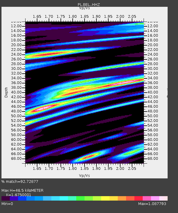
| Estimated Moho Depth: |
46.5 km |
| Estimated Crust Vp/Vs: |
1.68 |
| Assumed Crust Vp: |
6.426 km/s |
| Estimated Crust Vs: |
3.836 km/s |
| Estimated Crust Poisson's Ratio: |
0.22 |
|
| Radial Match: |
92.72877 % |
| Radial Bump: |
341 |
| Transverse Match: |
86.30243 % |
| Transverse Bump: |
400 |
| SOD ConfigId: |
18369291 |
| Insert Time: |
2019-07-10 02:28:26.482 +0000 |
| GWidth: |
2.5 |
| Max Bumps: |
400 |
| Tol: |
0.001 |
|

Signal To Noise
| Channel | StoN | STA | LTA |
| PL:BEL: :HHZ:20190626T02:28:36.970001Z | 24.549524 | 2.7234452E-7 | 1.1093679E-8 |
| PL:BEL: :HHN:20190626T02:28:36.970001Z | 7.355481 | 1.0365239E-7 | 1.4091858E-8 |
| PL:BEL: :HHE:20190626T02:28:36.970001Z | 1.0035537 | 1.2751189E-8 | 1.2706036E-8 |
| Arrivals |
| Ps | 5.1 SECOND |
| PpPs | 19 SECOND |
| PsPs/PpSs | 24 SECOND |


