You are here: Home > Network List > TA - USArray Transportable Network (new EarthScope stations) Stations List
> Station R31K City Hall, Gustavus, AK, USA > Earthquake Result Viewer
R31K City Hall, Gustavus, AK, USA - Earthquake Result Viewer

| Earthquake location: |
Komandorskiye Ostrova Region |
| Earthquake latitude/longitude: |
56.2/164.1 |
| Earthquake time(UTC): |
2019/06/26 (177) 02:18:07 GMT |
| Earthquake Depth: |
10 km |
| Earthquake Magnitude: |
6.4 Mww |
| Earthquake Catalog/Contributor: |
NEIC PDE/us |
|
| Network: |
TA USArray Transportable Network (new EarthScope stations) |
| Station: |
R31K City Hall, Gustavus, AK, USA |
| Lat/Lon: |
58.41 N/135.74 W |
| Elevation: |
15 m |
|
| Distance: |
31.6 deg |
| Az: |
60.532 deg |
| Baz: |
292.393 deg |
| Ray Param: |
0.07900123 |
| Estimated Moho Depth: |
10.5 km |
| Estimated Crust Vp/Vs: |
2.03 |
| Assumed Crust Vp: |
6.566 km/s |
| Estimated Crust Vs: |
3.239 km/s |
| Estimated Crust Poisson's Ratio: |
0.34 |
|
| Radial Match: |
84.60368 % |
| Radial Bump: |
400 |
| Transverse Match: |
45.737995 % |
| Transverse Bump: |
400 |
| SOD ConfigId: |
18369291 |
| Insert Time: |
2019-07-10 02:29:39.128 +0000 |
| GWidth: |
2.5 |
| Max Bumps: |
400 |
| Tol: |
0.001 |
|
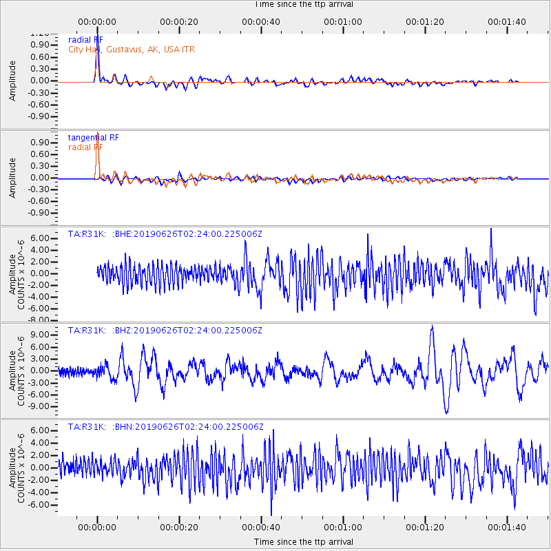
Signal To Noise
| Channel | StoN | STA | LTA |
| TA:R31K: :BHZ:20190626T02:24:00.225006Z | 2.5209014 | 1.5612585E-6 | 6.193255E-7 |
| TA:R31K: :BHN:20190626T02:24:00.225006Z | 0.90505046 | 1.0196406E-6 | 1.1266119E-6 |
| TA:R31K: :BHE:20190626T02:24:00.225006Z | 0.9633277 | 1.3912095E-6 | 1.4441705E-6 |
| Arrivals |
| Ps | 1.8 SECOND |
| PpPs | 4.5 SECOND |
| PsPs/PpSs | 6.3 SECOND |


