You are here: Home > Network List > TA - USArray Transportable Network (new EarthScope stations) Stations List
> Station U33K Whale Pass, AK, USA > Earthquake Result Viewer
U33K Whale Pass, AK, USA - Earthquake Result Viewer

| Earthquake location: |
Komandorskiye Ostrova Region |
| Earthquake latitude/longitude: |
56.2/164.1 |
| Earthquake time(UTC): |
2019/06/26 (177) 02:18:07 GMT |
| Earthquake Depth: |
10 km |
| Earthquake Magnitude: |
6.4 Mww |
| Earthquake Catalog/Contributor: |
NEIC PDE/us |
|
| Network: |
TA USArray Transportable Network (new EarthScope stations) |
| Station: |
U33K Whale Pass, AK, USA |
| Lat/Lon: |
56.11 N/133.12 W |
| Elevation: |
11 m |
|
| Distance: |
33.9 deg |
| Az: |
63.306 deg |
| Baz: |
296.926 deg |
| Ray Param: |
0.07800799 |
| Estimated Moho Depth: |
27.25 km |
| Estimated Crust Vp/Vs: |
1.95 |
| Assumed Crust Vp: |
6.597 km/s |
| Estimated Crust Vs: |
3.392 km/s |
| Estimated Crust Poisson's Ratio: |
0.32 |
|
| Radial Match: |
92.36039 % |
| Radial Bump: |
341 |
| Transverse Match: |
64.0128 % |
| Transverse Bump: |
400 |
| SOD ConfigId: |
18369291 |
| Insert Time: |
2019-07-10 02:29:43.721 +0000 |
| GWidth: |
2.5 |
| Max Bumps: |
400 |
| Tol: |
0.001 |
|
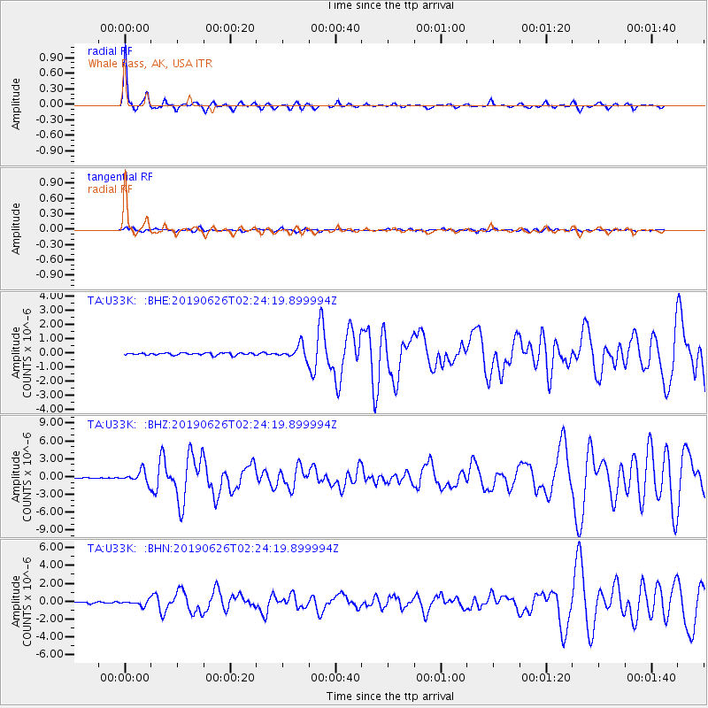
Signal To Noise
| Channel | StoN | STA | LTA |
| TA:U33K: :BHZ:20190626T02:24:19.899994Z | 10.060422 | 1.0114094E-6 | 1.0053349E-7 |
| TA:U33K: :BHN:20190626T02:24:19.899994Z | 4.094481 | 2.9872413E-7 | 7.2957754E-8 |
| TA:U33K: :BHE:20190626T02:24:19.899994Z | 6.136677 | 4.8913574E-7 | 7.9706936E-8 |
| Arrivals |
| Ps | 4.2 SECOND |
| PpPs | 11 SECOND |
| PsPs/PpSs | 15 SECOND |


