You are here: Home > Network List > TJ - Tajikistan National Seismic Network Stations List
> Station SHAA Shaartuz, Tajikistan > Earthquake Result Viewer
SHAA Shaartuz, Tajikistan - Earthquake Result Viewer
| Earthquake location: |
Komandorskiye Ostrova Region |
| Earthquake latitude/longitude: |
56.2/164.1 |
| Earthquake time(UTC): |
2019/06/26 (177) 02:18:07 GMT |
| Earthquake Depth: |
10 km |
| Earthquake Magnitude: |
6.4 Mww |
| Earthquake Catalog/Contributor: |
NEIC PDE/us |
|
| Network: |
TJ Tajikistan National Seismic Network |
| Station: |
SHAA Shaartuz, Tajikistan |
| Lat/Lon: |
37.56 N/68.12 E |
| Elevation: |
868 m |
|
| Distance: |
62.8 deg |
| Az: |
297.324 deg |
| Baz: |
38.676 deg |
| Ray Param: |
0.05997934 |
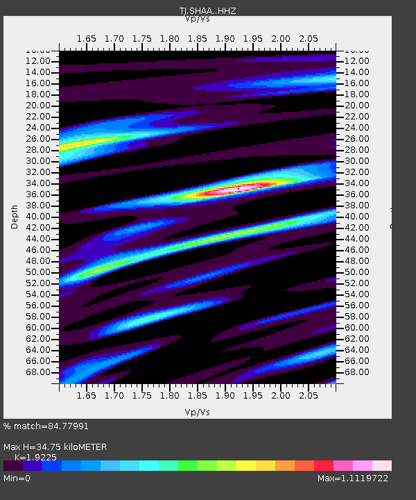
| Estimated Moho Depth: |
34.75 km |
| Estimated Crust Vp/Vs: |
1.92 |
| Assumed Crust Vp: |
6.213 km/s |
| Estimated Crust Vs: |
3.232 km/s |
| Estimated Crust Poisson's Ratio: |
0.31 |
|
| Radial Match: |
84.77991 % |
| Radial Bump: |
347 |
| Transverse Match: |
76.49433 % |
| Transverse Bump: |
334 |
| SOD ConfigId: |
18369291 |
| Insert Time: |
2019-07-10 02:29:53.024 +0000 |
| GWidth: |
2.5 |
| Max Bumps: |
400 |
| Tol: |
0.001 |
|

Signal To Noise
| Channel | StoN | STA | LTA |
| TJ:SHAA: :HHZ:20190626T02:28:02.50003Z | 98.005974 | 1.3969729E-5 | 1.4253956E-7 |
| TJ:SHAA: :HHN:20190626T02:28:02.50003Z | 47.051746 | 4.600802E-6 | 9.778175E-8 |
| TJ:SHAA: :HHE:20190626T02:28:02.50003Z | 17.041273 | 2.7896508E-6 | 1.6369967E-7 |
| Arrivals |
| Ps | 5.4 SECOND |
| PpPs | 16 SECOND |
| PsPs/PpSs | 21 SECOND |


