You are here: Home > Network List > TX - Texas Seismological Network Stations List
> Station ALPN Alpine > Earthquake Result Viewer
ALPN Alpine - Earthquake Result Viewer
| Earthquake location: |
Komandorskiye Ostrova Region |
| Earthquake latitude/longitude: |
56.2/164.1 |
| Earthquake time(UTC): |
2019/06/26 (177) 02:18:07 GMT |
| Earthquake Depth: |
10 km |
| Earthquake Magnitude: |
6.4 Mww |
| Earthquake Catalog/Contributor: |
NEIC PDE/us |
|
| Network: |
TX Texas Seismological Network |
| Station: |
ALPN Alpine |
| Lat/Lon: |
30.37 N/103.64 W |
| Elevation: |
1368 m |
|
| Distance: |
66.5 deg |
| Az: |
70.307 deg |
| Baz: |
322.485 deg |
| Ray Param: |
0.05756159 |
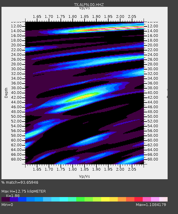
| Estimated Moho Depth: |
12.75 km |
| Estimated Crust Vp/Vs: |
1.98 |
| Assumed Crust Vp: |
6.121 km/s |
| Estimated Crust Vs: |
3.091 km/s |
| Estimated Crust Poisson's Ratio: |
0.33 |
|
| Radial Match: |
93.65946 % |
| Radial Bump: |
374 |
| Transverse Match: |
70.157074 % |
| Transverse Bump: |
400 |
| SOD ConfigId: |
18369291 |
| Insert Time: |
2019-07-10 02:30:06.240 +0000 |
| GWidth: |
2.5 |
| Max Bumps: |
400 |
| Tol: |
0.001 |
|

Signal To Noise
| Channel | StoN | STA | LTA |
| TX:ALPN:00:HHZ:20190626T02:28:26.62503Z | 8.1568775 | 8.3197375E-7 | 1.019966E-7 |
| TX:ALPN:00:HH1:20190626T02:28:26.62503Z | 1.5662994 | 1.4791131E-7 | 9.44336E-8 |
| TX:ALPN:00:HH2:20190626T02:28:26.62503Z | 10.217208 | 4.7561946E-7 | 4.6550824E-8 |
| Arrivals |
| Ps | 2.1 SECOND |
| PpPs | 6.0 SECOND |
| PsPs/PpSs | 8.1 SECOND |


