You are here: Home > Network List > CO - South Carolina Seismic Network Stations List
> Station HODGE CO:HODGE > Earthquake Result Viewer
HODGE CO:HODGE - Earthquake Result Viewer
| Earthquake location: |
Near Islands, Aleutian Islands |
| Earthquake latitude/longitude: |
52.2/174.2 |
| Earthquake time(UTC): |
2016/12/03 (338) 09:23:34 GMT |
| Earthquake Depth: |
27 km |
| Earthquake Magnitude: |
6.0 mb |
| Earthquake Catalog/Contributor: |
NEIC PDE/us |
|
| Network: |
CO South Carolina Seismic Network |
| Station: |
HODGE CO:HODGE |
| Lat/Lon: |
34.23 N/82.26 W |
| Elevation: |
151 m |
|
| Distance: |
71.2 deg |
| Az: |
58.31 deg |
| Baz: |
320.84 deg |
| Ray Param: |
0.05445131 |
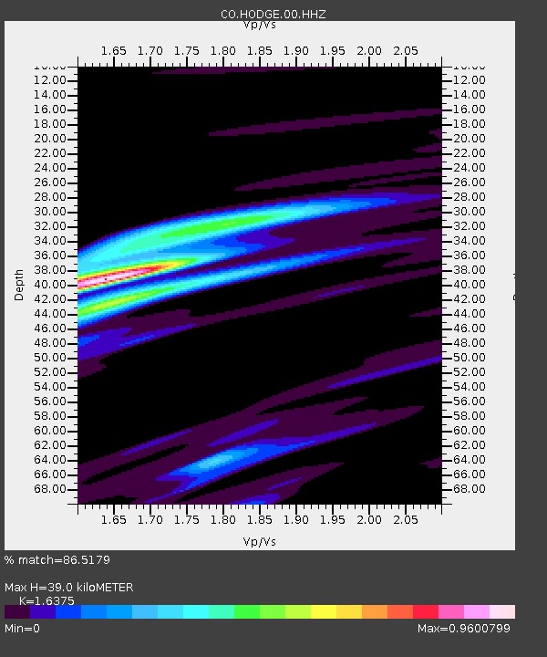
| Estimated Moho Depth: |
39.0 km |
| Estimated Crust Vp/Vs: |
1.64 |
| Assumed Crust Vp: |
6.35 km/s |
| Estimated Crust Vs: |
3.878 km/s |
| Estimated Crust Poisson's Ratio: |
0.20 |
|
| Radial Match: |
86.5179 % |
| Radial Bump: |
353 |
| Transverse Match: |
59.04123 % |
| Transverse Bump: |
400 |
| SOD ConfigId: |
1894071 |
| Insert Time: |
2016-12-17 09:24:55.925 +0000 |
| GWidth: |
2.5 |
| Max Bumps: |
400 |
| Tol: |
0.001 |
|

Signal To Noise
| Channel | StoN | STA | LTA |
| CO:HODGE:00:HHZ:20161203T09:34:20.300017Z | 1.80567 | 1.0187031E-6 | 5.64169E-7 |
| CO:HODGE:00:HHN:20161203T09:34:20.300017Z | 1.8634052 | 4.395044E-7 | 2.3586088E-7 |
| CO:HODGE:00:HHE:20161203T09:34:20.300017Z | 1.3242693 | 3.2092228E-7 | 2.4233915E-7 |
| Arrivals |
| Ps | 4.1 SECOND |
| PpPs | 16 SECOND |
| PsPs/PpSs | 20 SECOND |


