You are here: Home > Network List > TX - Texas Seismological Network Stations List
> Station PB13 Reeves - Culberson Border > Earthquake Result Viewer
PB13 Reeves - Culberson Border - Earthquake Result Viewer
| Earthquake location: |
Komandorskiye Ostrova Region |
| Earthquake latitude/longitude: |
56.2/164.1 |
| Earthquake time(UTC): |
2019/06/26 (177) 02:18:07 GMT |
| Earthquake Depth: |
10 km |
| Earthquake Magnitude: |
6.4 Mww |
| Earthquake Catalog/Contributor: |
NEIC PDE/us |
|
| Network: |
TX Texas Seismological Network |
| Station: |
PB13 Reeves - Culberson Border |
| Lat/Lon: |
31.55 N/103.85 W |
| Elevation: |
956 m |
|
| Distance: |
65.5 deg |
| Az: |
69.674 deg |
| Baz: |
322.122 deg |
| Ray Param: |
0.05824308 |
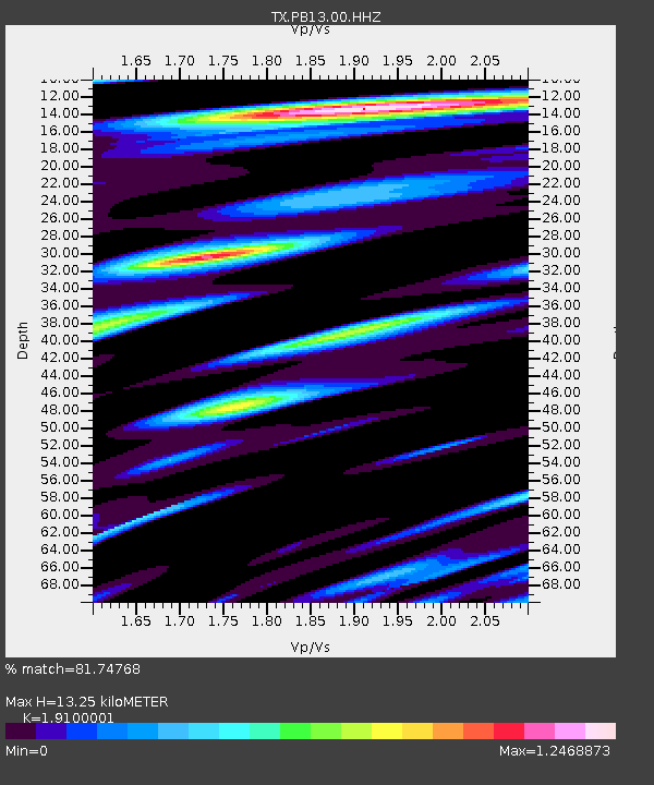
| Estimated Moho Depth: |
13.25 km |
| Estimated Crust Vp/Vs: |
1.91 |
| Assumed Crust Vp: |
6.121 km/s |
| Estimated Crust Vs: |
3.204 km/s |
| Estimated Crust Poisson's Ratio: |
0.31 |
|
| Radial Match: |
81.74768 % |
| Radial Bump: |
400 |
| Transverse Match: |
75.75607 % |
| Transverse Bump: |
400 |
| SOD ConfigId: |
18369291 |
| Insert Time: |
2019-07-10 02:30:45.133 +0000 |
| GWidth: |
2.5 |
| Max Bumps: |
400 |
| Tol: |
0.001 |
|

Signal To Noise
| Channel | StoN | STA | LTA |
| TX:PB13:00:HHZ:20190626T02:28:19.959991Z | 5.6316404 | 8.7461154E-7 | 1.5530317E-7 |
| TX:PB13:00:HHN:20190626T02:28:19.959991Z | 2.7778008 | 4.4741782E-7 | 1.6106908E-7 |
| TX:PB13:00:HHE:20190626T02:28:19.959991Z | 1.4439962 | 2.1877175E-7 | 1.5150438E-7 |
| Arrivals |
| Ps | 2.0 SECOND |
| PpPs | 6.1 SECOND |
| PsPs/PpSs | 8.1 SECOND |


