You are here: Home > Network List > CU - Caribbean Network (USGS) Stations List
> Station TGUH Tegucigalpa, Honduras > Earthquake Result Viewer
TGUH Tegucigalpa, Honduras - Earthquake Result Viewer
| Earthquake location: |
Near Islands, Aleutian Islands |
| Earthquake latitude/longitude: |
52.2/174.2 |
| Earthquake time(UTC): |
2016/12/03 (338) 09:23:34 GMT |
| Earthquake Depth: |
27 km |
| Earthquake Magnitude: |
6.0 mb |
| Earthquake Catalog/Contributor: |
NEIC PDE/us |
|
| Network: |
CU Caribbean Network (USGS) |
| Station: |
TGUH Tegucigalpa, Honduras |
| Lat/Lon: |
14.06 N/87.27 W |
| Elevation: |
0.0 m |
|
| Distance: |
84.2 deg |
| Az: |
74.738 deg |
| Baz: |
322.319 deg |
| Ray Param: |
0.045653004 |
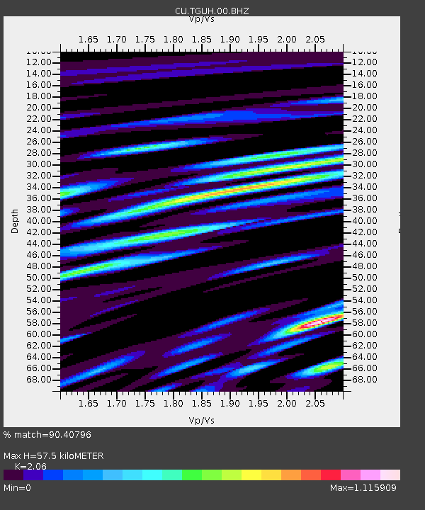
| Estimated Moho Depth: |
57.5 km |
| Estimated Crust Vp/Vs: |
2.06 |
| Assumed Crust Vp: |
6.597 km/s |
| Estimated Crust Vs: |
3.203 km/s |
| Estimated Crust Poisson's Ratio: |
0.35 |
|
| Radial Match: |
90.40796 % |
| Radial Bump: |
400 |
| Transverse Match: |
86.80213 % |
| Transverse Bump: |
400 |
| SOD ConfigId: |
1894071 |
| Insert Time: |
2016-12-17 09:25:09.685 +0000 |
| GWidth: |
2.5 |
| Max Bumps: |
400 |
| Tol: |
0.001 |
|

Signal To Noise
| Channel | StoN | STA | LTA |
| CU:TGUH:00:BHZ:20161203T09:35:32.274993Z | 25.799519 | 1.8519971E-6 | 7.178418E-8 |
| CU:TGUH:00:BH1:20161203T09:35:32.274993Z | 3.0414214 | 2.8008645E-7 | 9.2090644E-8 |
| CU:TGUH:00:BH2:20161203T09:35:32.274993Z | 6.937656 | 6.0215405E-7 | 8.679503E-8 |
| Arrivals |
| Ps | 9.5 SECOND |
| PpPs | 26 SECOND |
| PsPs/PpSs | 36 SECOND |


