You are here: Home > Network List > US - United States National Seismic Network Stations List
> Station OGNE Ogallala, Nebraska, USA > Earthquake Result Viewer
OGNE Ogallala, Nebraska, USA - Earthquake Result Viewer
| Earthquake location: |
Komandorskiye Ostrova Region |
| Earthquake latitude/longitude: |
56.2/164.1 |
| Earthquake time(UTC): |
2019/06/26 (177) 02:18:07 GMT |
| Earthquake Depth: |
10 km |
| Earthquake Magnitude: |
6.4 Mww |
| Earthquake Catalog/Contributor: |
NEIC PDE/us |
|
| Network: |
US United States National Seismic Network |
| Station: |
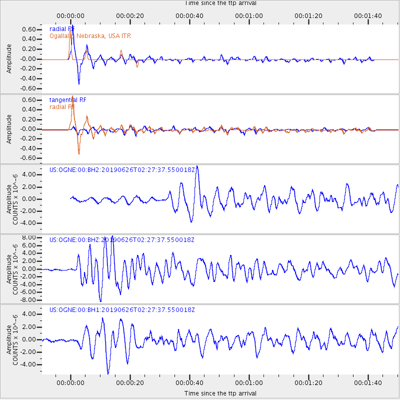
OGNE Ogallala, Nebraska, USA |
| Lat/Lon: |
40.95 N/102.03 W |
| Elevation: |
1054 m |
|
| Distance: |
59.1 deg |
| Az: |
61.704 deg |
| Baz: |
319.479 deg |
| Ray Param: |
0.062388483 |
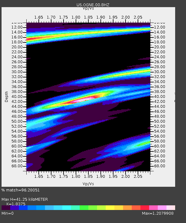
| Estimated Moho Depth: |
41.25 km |
| Estimated Crust Vp/Vs: |
1.84 |
| Assumed Crust Vp: |
6.483 km/s |
| Estimated Crust Vs: |
3.528 km/s |
| Estimated Crust Poisson's Ratio: |
0.29 |
|
| Radial Match: |
96.28051 % |
| Radial Bump: |
255 |
| Transverse Match: |
77.5698 % |
| Transverse Bump: |
386 |
| SOD ConfigId: |
18369291 |
| Insert Time: |
2019-07-10 02:31:26.255 +0000 |
| GWidth: |
2.5 |
| Max Bumps: |
400 |
| Tol: |
0.001 |
|
Signal To Noise
| Channel | StoN | STA | LTA |
| US:OGNE:00:BHZ:20190626T02:27:37.550018Z | 19.710705 | 1.9178979E-6 | 9.730235E-8 |
| US:OGNE:00:BH1:20190626T02:27:37.550018Z | 3.5356886 | 5.9259827E-7 | 1.6760477E-7 |
| US:OGNE:00:BH2:20190626T02:27:37.550018Z | 1.6721565 | 6.0118674E-7 | 3.595278E-7 |
| Arrivals |
| Ps | 5.6 SECOND |
| PpPs | 17 SECOND |
| PsPs/PpSs | 23 SECOND |


