You are here: Home > Network List > US - United States National Seismic Network Stations List
> Station SDCO Great Sand Dunes National Park, Colorado, USA > Earthquake Result Viewer
SDCO Great Sand Dunes National Park, Colorado, USA - Earthquake Result Viewer
| Earthquake location: |
Komandorskiye Ostrova Region |
| Earthquake latitude/longitude: |
56.2/164.1 |
| Earthquake time(UTC): |
2019/06/26 (177) 02:18:07 GMT |
| Earthquake Depth: |
10 km |
| Earthquake Magnitude: |
6.4 Mww |
| Earthquake Catalog/Contributor: |
NEIC PDE/us |
|
| Network: |
US United States National Seismic Network |
| Station: |
SDCO Great Sand Dunes National Park, Colorado, USA |
| Lat/Lon: |
37.75 N/105.50 W |
| Elevation: |
2569 m |
|
| Distance: |
59.8 deg |
| Az: |
66.485 deg |
| Baz: |
319.717 deg |
| Ray Param: |
0.061934173 |
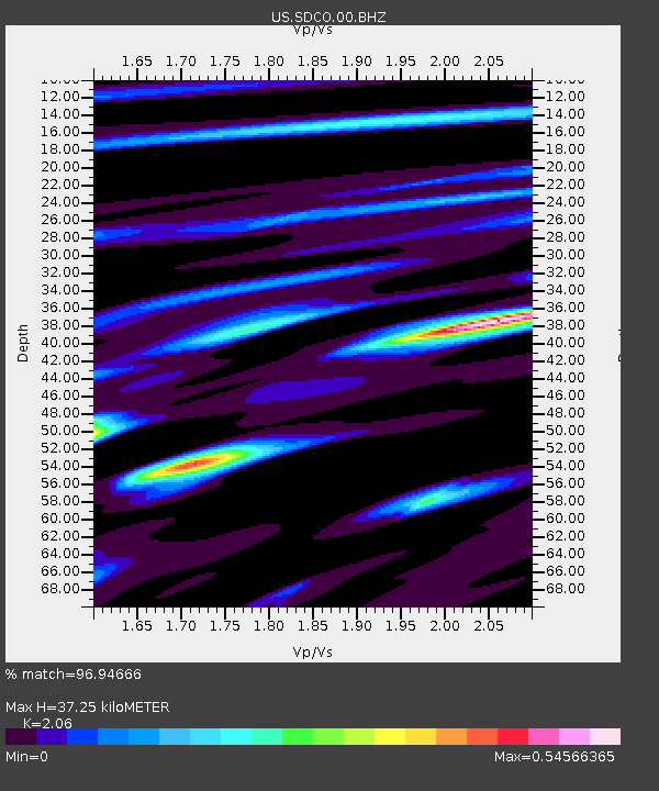
| Estimated Moho Depth: |
37.25 km |
| Estimated Crust Vp/Vs: |
2.06 |
| Assumed Crust Vp: |
6.316 km/s |
| Estimated Crust Vs: |
3.066 km/s |
| Estimated Crust Poisson's Ratio: |
0.35 |
|
| Radial Match: |
96.94666 % |
| Radial Bump: |
335 |
| Transverse Match: |
92.303856 % |
| Transverse Bump: |
400 |
| SOD ConfigId: |
18369291 |
| Insert Time: |
2019-07-10 02:31:29.188 +0000 |
| GWidth: |
2.5 |
| Max Bumps: |
400 |
| Tol: |
0.001 |
|
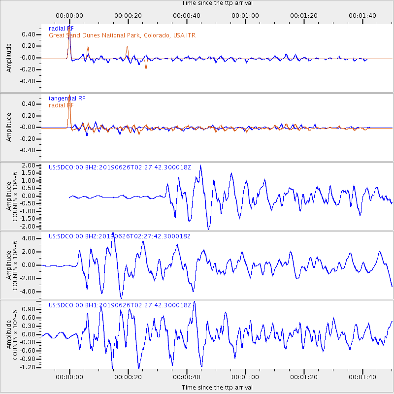
Signal To Noise
| Channel | StoN | STA | LTA |
| US:SDCO:00:BHZ:20190626T02:27:42.300018Z | 10.557721 | 8.2724534E-7 | 7.835454E-8 |
| US:SDCO:00:BH1:20190626T02:27:42.300018Z | 2.92392 | 1.754661E-7 | 6.001057E-8 |
| US:SDCO:00:BH2:20190626T02:27:42.300018Z | 5.785028 | 2.944731E-7 | 5.090262E-8 |
| Arrivals |
| Ps | 6.5 SECOND |
| PpPs | 17 SECOND |
| PsPs/PpSs | 24 SECOND |


