You are here: Home > Network List > UU - University of Utah Regional Network Stations List
> Station KNB Kanab, UT, USA > Earthquake Result Viewer
KNB Kanab, UT, USA - Earthquake Result Viewer
| Earthquake location: |
Komandorskiye Ostrova Region |
| Earthquake latitude/longitude: |
56.2/164.1 |
| Earthquake time(UTC): |
2019/06/26 (177) 02:18:07 GMT |
| Earthquake Depth: |
10 km |
| Earthquake Magnitude: |
6.4 Mww |
| Earthquake Catalog/Contributor: |
NEIC PDE/us |
|
| Network: |
UU University of Utah Regional Network |
| Station: |
KNB Kanab, UT, USA |
| Lat/Lon: |
37.02 N/112.82 W |
| Elevation: |
1715 m |
|
| Distance: |
56.5 deg |
| Az: |
72.225 deg |
| Baz: |
318.316 deg |
| Ray Param: |
0.06407107 |
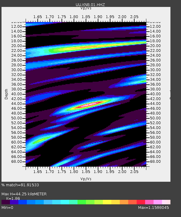
| Estimated Moho Depth: |
44.25 km |
| Estimated Crust Vp/Vs: |
1.86 |
| Assumed Crust Vp: |
6.194 km/s |
| Estimated Crust Vs: |
3.33 km/s |
| Estimated Crust Poisson's Ratio: |
0.30 |
|
| Radial Match: |
91.91533 % |
| Radial Bump: |
386 |
| Transverse Match: |
80.74765 % |
| Transverse Bump: |
388 |
| SOD ConfigId: |
18369291 |
| Insert Time: |
2019-07-10 02:31:42.227 +0000 |
| GWidth: |
2.5 |
| Max Bumps: |
400 |
| Tol: |
0.001 |
|
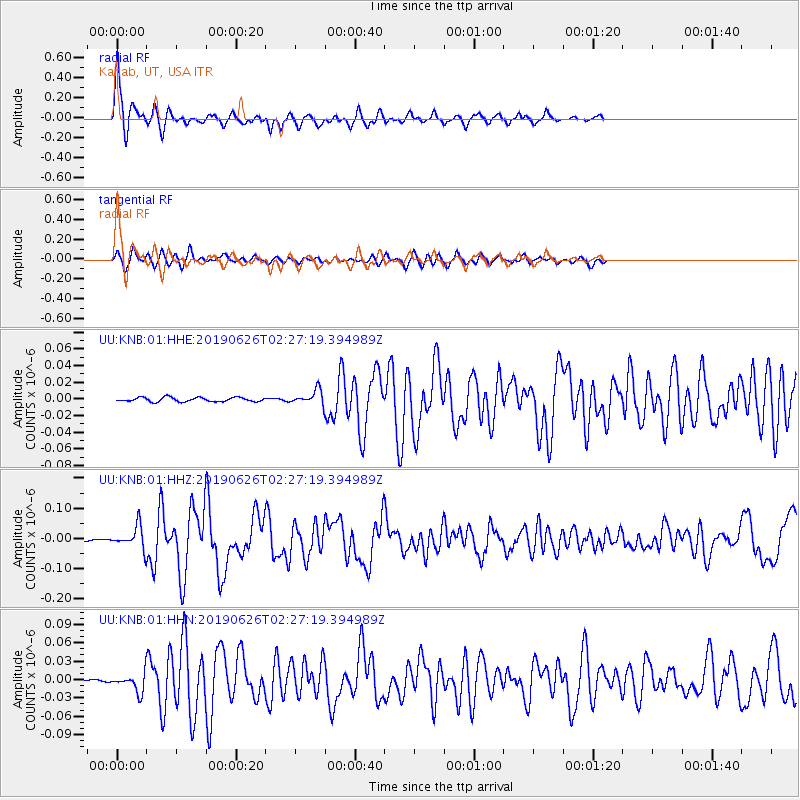
Signal To Noise
| Channel | StoN | STA | LTA |
| UU:KNB:01:HHZ:20190626T02:27:19.394989Z | 16.566963 | 3.6278774E-8 | 2.1898263E-9 |
| UU:KNB:01:HHN:20190626T02:27:19.394989Z | 6.118886 | 1.4398295E-8 | 2.353091E-9 |
| UU:KNB:01:HHE:20190626T02:27:19.394989Z | 3.3993511 | 8.392715E-9 | 2.4689166E-9 |
| Arrivals |
| Ps | 6.4 SECOND |
| PpPs | 20 SECOND |
| PsPs/PpSs | 26 SECOND |


