You are here: Home > Network List > UU - University of Utah Regional Network Stations List
> Station TCU Toone Canyon, UT, USA > Earthquake Result Viewer
TCU Toone Canyon, UT, USA - Earthquake Result Viewer
| Earthquake location: |
Komandorskiye Ostrova Region |
| Earthquake latitude/longitude: |
56.2/164.1 |
| Earthquake time(UTC): |
2019/06/26 (177) 02:18:07 GMT |
| Earthquake Depth: |
10 km |
| Earthquake Magnitude: |
6.4 Mww |
| Earthquake Catalog/Contributor: |
NEIC PDE/us |
|
| Network: |
UU University of Utah Regional Network |
| Station: |
TCU Toone Canyon, UT, USA |
| Lat/Lon: |
41.12 N/111.41 W |
| Elevation: |
2269 m |
|
| Distance: |
54.3 deg |
| Az: |
67.88 deg |
| Baz: |
316.736 deg |
| Ray Param: |
0.06555349 |
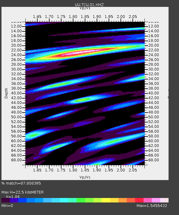
| Estimated Moho Depth: |
22.5 km |
| Estimated Crust Vp/Vs: |
1.84 |
| Assumed Crust Vp: |
6.155 km/s |
| Estimated Crust Vs: |
3.345 km/s |
| Estimated Crust Poisson's Ratio: |
0.29 |
|
| Radial Match: |
87.808395 % |
| Radial Bump: |
400 |
| Transverse Match: |
85.3474 % |
| Transverse Bump: |
400 |
| SOD ConfigId: |
18369291 |
| Insert Time: |
2019-07-10 02:31:48.533 +0000 |
| GWidth: |
2.5 |
| Max Bumps: |
400 |
| Tol: |
0.001 |
|

Signal To Noise
| Channel | StoN | STA | LTA |
| UU:TCU:01:HHZ:20190626T02:27:03.024994Z | 11.318512 | 3.459682E-8 | 3.056658E-9 |
| UU:TCU:01:HHN:20190626T02:27:03.024994Z | 5.3952417 | 1.743957E-8 | 3.2323981E-9 |
| UU:TCU:01:HHE:20190626T02:27:03.024994Z | 4.586862 | 1.8152512E-8 | 3.957501E-9 |
| Arrivals |
| Ps | 3.2 SECOND |
| PpPs | 9.9 SECOND |
| PsPs/PpSs | 13 SECOND |


