You are here: Home > Network List > UW - Pacific Northwest Regional Seismic Network Stations List
> Station BABR Baber Butte, OR, USA > Earthquake Result Viewer
BABR Baber Butte, OR, USA - Earthquake Result Viewer
| Earthquake location: |
Komandorskiye Ostrova Region |
| Earthquake latitude/longitude: |
56.2/164.1 |
| Earthquake time(UTC): |
2019/06/26 (177) 02:18:07 GMT |
| Earthquake Depth: |
10 km |
| Earthquake Magnitude: |
6.4 Mww |
| Earthquake Catalog/Contributor: |
NEIC PDE/us |
|
| Network: |
UW Pacific Northwest Regional Seismic Network |
| Station: |
BABR Baber Butte, OR, USA |
| Lat/Lon: |
44.62 N/123.79 W |
| Elevation: |
439 m |
|
| Distance: |
45.3 deg |
| Az: |
72.897 deg |
| Baz: |
311.572 deg |
| Ray Param: |
0.07136382 |
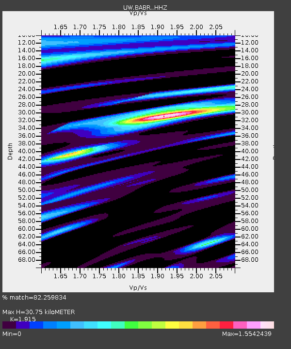
| Estimated Moho Depth: |
30.75 km |
| Estimated Crust Vp/Vs: |
1.91 |
| Assumed Crust Vp: |
6.566 km/s |
| Estimated Crust Vs: |
3.429 km/s |
| Estimated Crust Poisson's Ratio: |
0.31 |
|
| Radial Match: |
82.259834 % |
| Radial Bump: |
365 |
| Transverse Match: |
72.685524 % |
| Transverse Bump: |
400 |
| SOD ConfigId: |
18369291 |
| Insert Time: |
2019-07-10 02:31:50.502 +0000 |
| GWidth: |
2.5 |
| Max Bumps: |
400 |
| Tol: |
0.001 |
|

Signal To Noise
| Channel | StoN | STA | LTA |
| UW:BABR: :HHZ:20190626T02:25:54.950012Z | 3.4133856 | 1.4244862E-6 | 4.1732355E-7 |
| UW:BABR: :HHN:20190626T02:25:54.950012Z | 1.0781252 | 3.6408449E-7 | 3.3770147E-7 |
| UW:BABR: :HHE:20190626T02:25:54.950012Z | 1.3829771 | 5.5659007E-7 | 4.0245786E-7 |
| Arrivals |
| Ps | 4.6 SECOND |
| PpPs | 13 SECOND |
| PsPs/PpSs | 17 SECOND |


