You are here: Home > Network List > TA - USArray Transportable Network (new EarthScope stations) Stations List
> Station A19A Klindworth Farms, Hogeland, MT, USA > Earthquake Result Viewer
A19A Klindworth Farms, Hogeland, MT, USA - Earthquake Result Viewer
| Earthquake location: |
Honduras |
| Earthquake latitude/longitude: |
15.8/-86.9 |
| Earthquake time(UTC): |
2009/06/08 (159) 05:13:14 GMT |
| Earthquake Depth: |
10 km |
| Earthquake Magnitude: |
5.5 MB, 4.9 MS, 5.4 MW, 5.4 MW |
| Earthquake Catalog/Contributor: |
WHDF/NEIC |
|
| Network: |
TA USArray Transportable Network (new EarthScope stations) |
| Station: |
A19A Klindworth Farms, Hogeland, MT, USA |
| Lat/Lon: |
48.93 N/108.74 W |
| Elevation: |
971 m |
|
| Distance: |
37.6 deg |
| Az: |
336.237 deg |
| Baz: |
143.969 deg |
| Ray Param: |
0.07605849 |
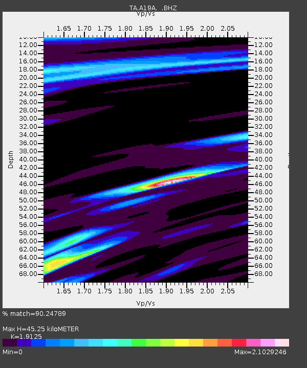
| Estimated Moho Depth: |
45.25 km |
| Estimated Crust Vp/Vs: |
1.91 |
| Assumed Crust Vp: |
6.438 km/s |
| Estimated Crust Vs: |
3.366 km/s |
| Estimated Crust Poisson's Ratio: |
0.31 |
|
| Radial Match: |
90.24789 % |
| Radial Bump: |
351 |
| Transverse Match: |
65.65876 % |
| Transverse Bump: |
391 |
| SOD ConfigId: |
2648 |
| Insert Time: |
2010-03-07 00:45:09.053 +0000 |
| GWidth: |
2.5 |
| Max Bumps: |
400 |
| Tol: |
0.001 |
|

Signal To Noise
| Channel | StoN | STA | LTA |
| TA:A19A: :BHZ:20090608T05:19:58.375007Z | 2.8497045 | 5.086967E-7 | 1.7850859E-7 |
| TA:A19A: :BHN:20090608T05:19:58.375007Z | 1.8190058 | 3.050257E-7 | 1.6768814E-7 |
| TA:A19A: :BHE:20090608T05:19:58.375007Z | 1.4567964 | 2.3065131E-7 | 1.5832777E-7 |
| Arrivals |
| Ps | 6.9 SECOND |
| PpPs | 19 SECOND |
| PsPs/PpSs | 26 SECOND |


