You are here: Home > Network List > UW - Pacific Northwest Regional Seismic Network Stations List
> Station H2O H2O, Hanford, WA, USA > Earthquake Result Viewer
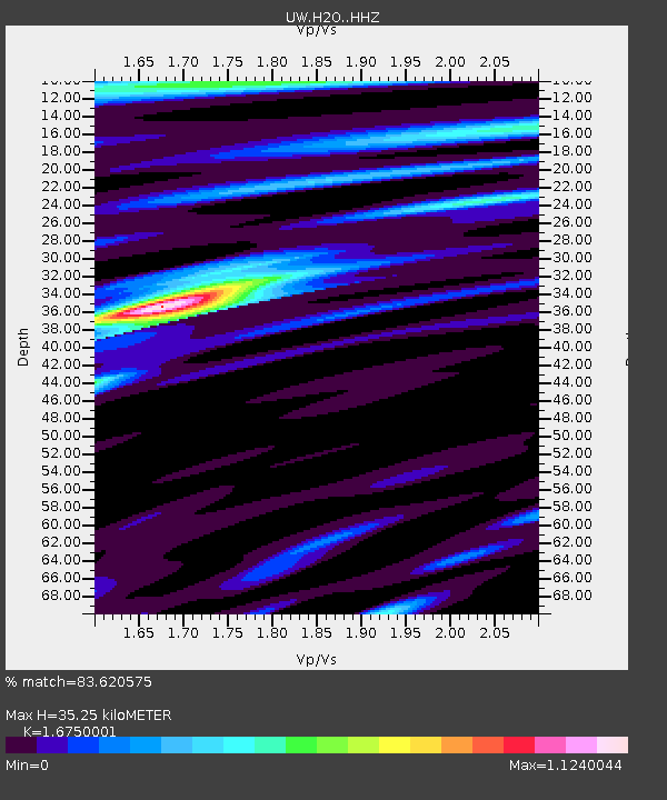
H2O H2O, Hanford, WA, USA - Earthquake Result Viewer
| Earthquake location: |
Komandorskiye Ostrova Region |
| Earthquake latitude/longitude: |
56.2/164.1 |
| Earthquake time(UTC): |
2019/06/26 (177) 02:18:07 GMT |
| Earthquake Depth: |
10 km |
| Earthquake Magnitude: |
6.4 Mww |
| Earthquake Catalog/Contributor: |
NEIC PDE/us |
|
| Network: |
UW Pacific Northwest Regional Seismic Network |
| Station: |
H2O H2O, Hanford, WA, USA |
| Lat/Lon: |
46.40 N/119.42 W |
| Elevation: |
175 m |
|
| Distance: |
46.4 deg |
| Az: |
68.213 deg |
| Baz: |
311.414 deg |
| Ray Param: |
0.07064727 |
| Estimated Moho Depth: |
35.25 km |
| Estimated Crust Vp/Vs: |
1.68 |
| Assumed Crust Vp: |
6.419 km/s |
| Estimated Crust Vs: |
3.832 km/s |
| Estimated Crust Poisson's Ratio: |
0.22 |
|
| Radial Match: |
83.620575 % |
| Radial Bump: |
400 |
| Transverse Match: |
67.63177 % |
| Transverse Bump: |
400 |
| SOD ConfigId: |
18369291 |
| Insert Time: |
2019-07-10 02:31:58.332 +0000 |
| GWidth: |
2.5 |
| Max Bumps: |
400 |
| Tol: |
0.001 |
|

Signal To Noise
| Channel | StoN | STA | LTA |
| UW:H2O: :HHZ:20190626T02:26:03.820007Z | 20.679375 | 1.4896883E-6 | 7.20374E-8 |
| UW:H2O: :HHN:20190626T02:26:03.820007Z | 6.240019 | 4.126571E-7 | 6.6130745E-8 |
| UW:H2O: :HHE:20190626T02:26:03.820007Z | 7.622495 | 5.364924E-7 | 7.038278E-8 |
| Arrivals |
| Ps | 4.0 SECOND |
| PpPs | 14 SECOND |
| PsPs/PpSs | 18 SECOND |


