You are here: Home > Network List > TA - USArray Transportable Network (new EarthScope stations) Stations List
> Station A19A Klindworth Farms, Hogeland, MT, USA > Earthquake Result Viewer
A19A Klindworth Farms, Hogeland, MT, USA - Earthquake Result Viewer
| Earthquake location: |
South Of Panama |
| Earthquake latitude/longitude: |
5.7/-82.8 |
| Earthquake time(UTC): |
2009/03/12 (071) 23:23:34 GMT |
| Earthquake Depth: |
9.0 km |
| Earthquake Magnitude: |
6.1 MB, 5.9 MS, 6.3 MW, 6.2 MW |
| Earthquake Catalog/Contributor: |
WHDF/NEIC |
|
| Network: |
TA USArray Transportable Network (new EarthScope stations) |
| Station: |
A19A Klindworth Farms, Hogeland, MT, USA |
| Lat/Lon: |
48.93 N/108.74 W |
| Elevation: |
971 m |
|
| Distance: |
48.4 deg |
| Az: |
337.275 deg |
| Baz: |
144.345 deg |
| Ray Param: |
0.06939253 |
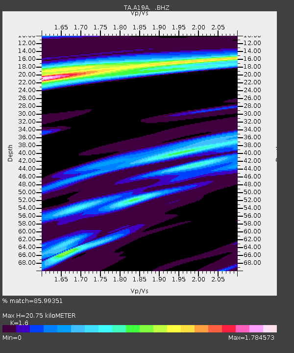
| Estimated Moho Depth: |
20.75 km |
| Estimated Crust Vp/Vs: |
1.60 |
| Assumed Crust Vp: |
6.438 km/s |
| Estimated Crust Vs: |
4.023 km/s |
| Estimated Crust Poisson's Ratio: |
0.18 |
|
| Radial Match: |
85.99351 % |
| Radial Bump: |
294 |
| Transverse Match: |
77.66547 % |
| Transverse Bump: |
400 |
| SOD ConfigId: |
2658 |
| Insert Time: |
2010-03-07 00:45:11.259 +0000 |
| GWidth: |
2.5 |
| Max Bumps: |
400 |
| Tol: |
0.001 |
|

Signal To Noise
| Channel | StoN | STA | LTA |
| TA:A19A: :BHZ:20090312T23:31:46.098992Z | 20.55789 | 2.7446188E-6 | 1.3350683E-7 |
| TA:A19A: :BHN:20090312T23:31:46.098992Z | 2.3408816 | 8.237016E-7 | 3.5187665E-7 |
| TA:A19A: :BHE:20090312T23:31:46.098992Z | 0.73591137 | 3.456631E-7 | 4.697075E-7 |
| Arrivals |
| Ps | 2.1 SECOND |
| PpPs | 7.8 SECOND |
| PsPs/PpSs | 9.9 SECOND |


