You are here: Home > Network List > UW - Pacific Northwest Regional Seismic Network Stations List
> Station LNO Lincton Mt., Oregon previous ISC code: LNOR > Earthquake Result Viewer
LNO Lincton Mt., Oregon previous ISC code: LNOR - Earthquake Result Viewer
| Earthquake location: |
Komandorskiye Ostrova Region |
| Earthquake latitude/longitude: |
56.2/164.1 |
| Earthquake time(UTC): |
2019/06/26 (177) 02:18:07 GMT |
| Earthquake Depth: |
10 km |
| Earthquake Magnitude: |
6.4 Mww |
| Earthquake Catalog/Contributor: |
NEIC PDE/us |
|
| Network: |
UW Pacific Northwest Regional Seismic Network |
| Station: |
LNO Lincton Mt., Oregon previous ISC code: LNOR |
| Lat/Lon: |
45.87 N/118.29 W |
| Elevation: |
771 m |
|
| Distance: |
47.4 deg |
| Az: |
68.027 deg |
| Baz: |
312.104 deg |
| Ray Param: |
0.070033886 |
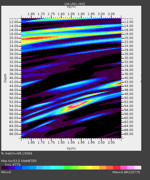
| Estimated Moho Depth: |
53.0 km |
| Estimated Crust Vp/Vs: |
1.88 |
| Assumed Crust Vp: |
6.571 km/s |
| Estimated Crust Vs: |
3.5 km/s |
| Estimated Crust Poisson's Ratio: |
0.30 |
|
| Radial Match: |
89.10084 % |
| Radial Bump: |
350 |
| Transverse Match: |
66.74558 % |
| Transverse Bump: |
400 |
| SOD ConfigId: |
18369291 |
| Insert Time: |
2019-07-10 02:32:04.948 +0000 |
| GWidth: |
2.5 |
| Max Bumps: |
400 |
| Tol: |
0.001 |
|

Signal To Noise
| Channel | StoN | STA | LTA |
| UW:LNO: :HHZ:20190626T02:26:11.140014Z | 21.001997 | 1.574682E-6 | 7.497773E-8 |
| UW:LNO: :HHN:20190626T02:26:11.140014Z | 4.428548 | 2.9988823E-7 | 6.771706E-8 |
| UW:LNO: :HHE:20190626T02:26:11.140014Z | 4.6091695 | 3.9179884E-7 | 8.500422E-8 |
| Arrivals |
| Ps | 7.5 SECOND |
| PpPs | 22 SECOND |
| PsPs/PpSs | 29 SECOND |


