You are here: Home > Network List > TA - USArray Transportable Network (new EarthScope stations) Stations List
> Station A19A Klindworth Farms, Hogeland, MT, USA > Earthquake Result Viewer
A19A Klindworth Farms, Hogeland, MT, USA - Earthquake Result Viewer
| Earthquake location: |
Guatemala |
| Earthquake latitude/longitude: |
14.6/-91.2 |
| Earthquake time(UTC): |
2009/05/03 (123) 16:21:47 GMT |
| Earthquake Depth: |
124 km |
| Earthquake Magnitude: |
5.6 MB, 6.2 MW, 6.2 MW |
| Earthquake Catalog/Contributor: |
WHDF/NEIC |
|
| Network: |
TA USArray Transportable Network (new EarthScope stations) |
| Station: |
A19A Klindworth Farms, Hogeland, MT, USA |
| Lat/Lon: |
48.93 N/108.74 W |
| Elevation: |
971 m |
|
| Distance: |
37.2 deg |
| Az: |
340.764 deg |
| Baz: |
151.072 deg |
| Ray Param: |
0.07584854 |
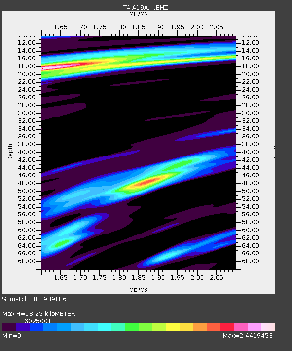
| Estimated Moho Depth: |
18.25 km |
| Estimated Crust Vp/Vs: |
1.60 |
| Assumed Crust Vp: |
6.438 km/s |
| Estimated Crust Vs: |
4.017 km/s |
| Estimated Crust Poisson's Ratio: |
0.18 |
|
| Radial Match: |
81.939186 % |
| Radial Bump: |
400 |
| Transverse Match: |
63.0223 % |
| Transverse Bump: |
400 |
| SOD ConfigId: |
2658 |
| Insert Time: |
2010-03-07 00:45:17.347 +0000 |
| GWidth: |
2.5 |
| Max Bumps: |
400 |
| Tol: |
0.001 |
|
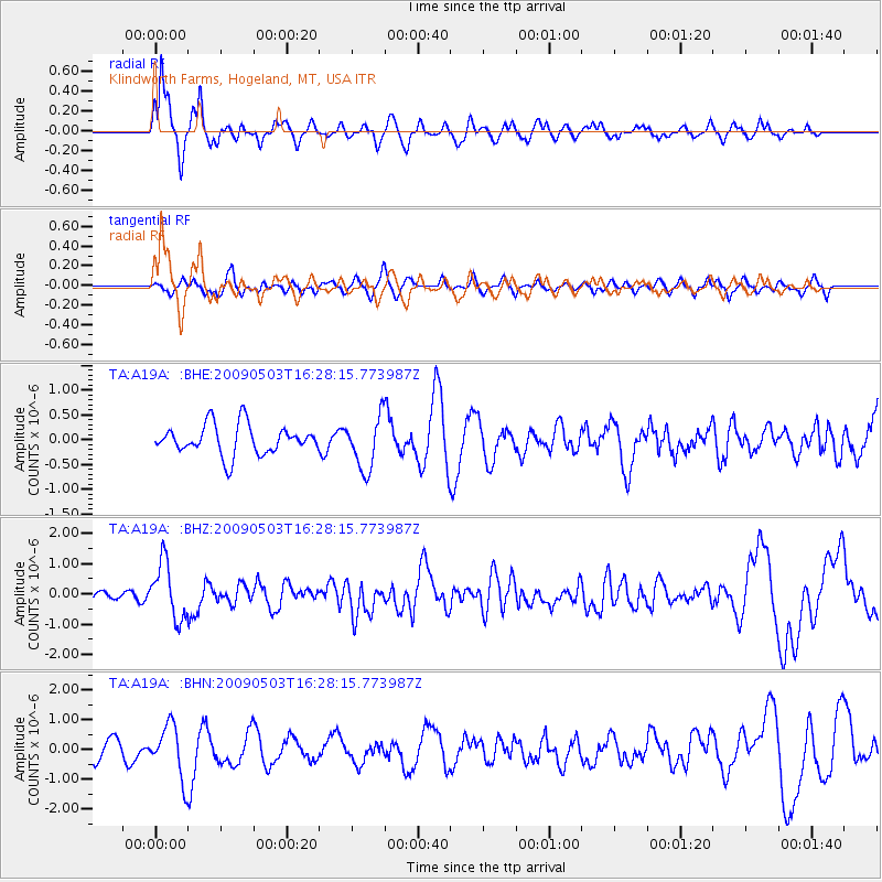
Signal To Noise
| Channel | StoN | STA | LTA |
| TA:A19A: :BHZ:20090503T16:28:15.773987Z | 7.023141 | 9.259276E-7 | 1.3183953E-7 |
| TA:A19A: :BHN:20090503T16:28:15.773987Z | 2.282478 | 8.893072E-7 | 3.8962352E-7 |
| TA:A19A: :BHE:20090503T16:28:15.773987Z | 1.7849282 | 5.2751426E-7 | 2.955381E-7 |
| Arrivals |
| Ps | 1.9 SECOND |
| PpPs | 6.8 SECOND |
| PsPs/PpSs | 8.7 SECOND |


