You are here: Home > Network List > UW - Pacific Northwest Regional Seismic Network Stations List
> Station WA2 Wahluke Slope previous ISC code: WAH2 > Earthquake Result Viewer
WA2 Wahluke Slope previous ISC code: WAH2 - Earthquake Result Viewer
| Earthquake location: |
Komandorskiye Ostrova Region |
| Earthquake latitude/longitude: |
56.2/164.1 |
| Earthquake time(UTC): |
2019/06/26 (177) 02:18:07 GMT |
| Earthquake Depth: |
10 km |
| Earthquake Magnitude: |
6.4 Mww |
| Earthquake Catalog/Contributor: |
NEIC PDE/us |
|
| Network: |
UW Pacific Northwest Regional Seismic Network |
| Station: |
WA2 Wahluke Slope previous ISC code: WAH2 |
| Lat/Lon: |
46.76 N/119.57 W |
| Elevation: |
244 m |
|
| Distance: |
46.1 deg |
| Az: |
67.929 deg |
| Baz: |
311.114 deg |
| Ray Param: |
0.070840165 |
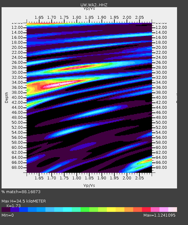
| Estimated Moho Depth: |
34.5 km |
| Estimated Crust Vp/Vs: |
1.73 |
| Assumed Crust Vp: |
6.419 km/s |
| Estimated Crust Vs: |
3.711 km/s |
| Estimated Crust Poisson's Ratio: |
0.25 |
|
| Radial Match: |
88.16873 % |
| Radial Bump: |
400 |
| Transverse Match: |
73.91245 % |
| Transverse Bump: |
400 |
| SOD ConfigId: |
18369291 |
| Insert Time: |
2019-07-10 02:32:15.719 +0000 |
| GWidth: |
2.5 |
| Max Bumps: |
400 |
| Tol: |
0.001 |
|

Signal To Noise
| Channel | StoN | STA | LTA |
| UW:WA2: :HHZ:20190626T02:26:01.369995Z | 20.136621 | 1.638372E-6 | 8.13628E-8 |
| UW:WA2: :HHN:20190626T02:26:01.369995Z | 6.4343705 | 5.2992704E-7 | 8.2358795E-8 |
| UW:WA2: :HHE:20190626T02:26:01.369995Z | 5.7509766 | 5.2887697E-7 | 9.196298E-8 |
| Arrivals |
| Ps | 4.2 SECOND |
| PpPs | 14 SECOND |
| PsPs/PpSs | 18 SECOND |


