You are here: Home > Network List > TA - USArray Transportable Network (new EarthScope stations) Stations List
> Station A19A Klindworth Farms, Hogeland, MT, USA > Earthquake Result Viewer
A19A Klindworth Farms, Hogeland, MT, USA - Earthquake Result Viewer

| Earthquake location: |
Kuril Islands |
| Earthquake latitude/longitude: |
46.0/151.5 |
| Earthquake time(UTC): |
2009/04/07 (097) 04:23:33 GMT |
| Earthquake Depth: |
31 km |
| Earthquake Magnitude: |
6.5 MB, 6.8 MS, 6.9 MW, 6.9 MW |
| Earthquake Catalog/Contributor: |
WHDF/NEIC |
|
| Network: |
TA USArray Transportable Network (new EarthScope stations) |
| Station: |
A19A Klindworth Farms, Hogeland, MT, USA |
| Lat/Lon: |
48.93 N/108.74 W |
| Elevation: |
971 m |
|
| Distance: |
62.5 deg |
| Az: |
47.135 deg |
| Baz: |
309.284 deg |
| Ray Param: |
0.06014393 |
| Estimated Moho Depth: |
66.0 km |
| Estimated Crust Vp/Vs: |
1.63 |
| Assumed Crust Vp: |
6.438 km/s |
| Estimated Crust Vs: |
3.955 km/s |
| Estimated Crust Poisson's Ratio: |
0.20 |
|
| Radial Match: |
96.19233 % |
| Radial Bump: |
322 |
| Transverse Match: |
83.6655 % |
| Transverse Bump: |
400 |
| SOD ConfigId: |
2658 |
| Insert Time: |
2010-03-07 00:45:19.107 +0000 |
| GWidth: |
2.5 |
| Max Bumps: |
400 |
| Tol: |
0.001 |
|
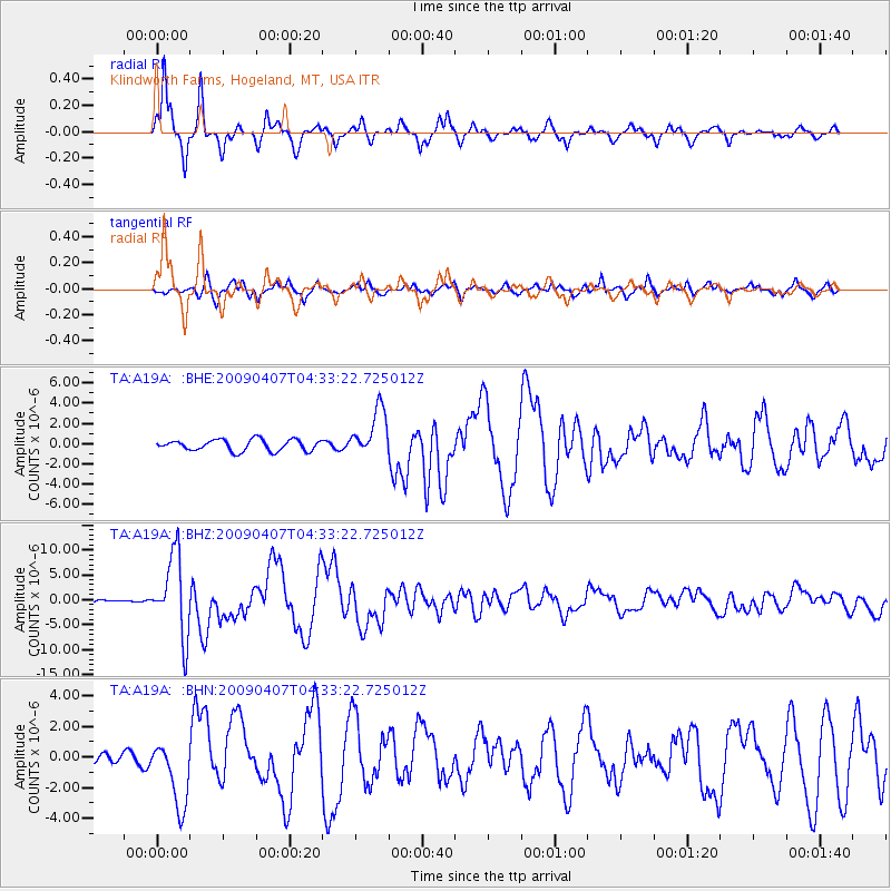
Signal To Noise
| Channel | StoN | STA | LTA |
| TA:A19A: :BHZ:20090407T04:33:22.725012Z | 31.590849 | 7.977663E-6 | 2.525308E-7 |
| TA:A19A: :BHN:20090407T04:33:22.725012Z | 4.2965093 | 2.1872854E-6 | 5.0908426E-7 |
| TA:A19A: :BHE:20090407T04:33:22.725012Z | 4.3183427 | 2.3621287E-6 | 5.4699893E-7 |
| Arrivals |
| Ps | 6.8 SECOND |
| PpPs | 26 SECOND |
| PsPs/PpSs | 32 SECOND |


