You are here: Home > Network List > II - Global Seismograph Network (GSN - IRIS/IDA) Stations List
> Station CMLA Cha de Macela, Sao Miguel Island, Azores > Earthquake Result Viewer
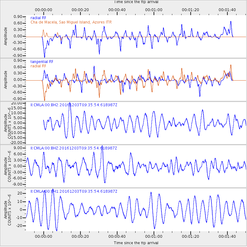
CMLA Cha de Macela, Sao Miguel Island, Azores - Earthquake Result Viewer
*The percent match for this event was below the threshold and hence no stack was calculated.
| Earthquake location: |
Near Islands, Aleutian Islands |
| Earthquake latitude/longitude: |
52.2/174.2 |
| Earthquake time(UTC): |
2016/12/03 (338) 09:23:34 GMT |
| Earthquake Depth: |
27 km |
| Earthquake Magnitude: |
6.0 mb |
| Earthquake Catalog/Contributor: |
NEIC PDE/us |
|
| Network: |
II Global Seismograph Network (GSN - IRIS/IDA) |
| Station: |
CMLA Cha de Macela, Sao Miguel Island, Azores |
| Lat/Lon: |
37.76 N/25.52 W |
| Elevation: |
429 m |
|
| Distance: |
88.7 deg |
| Az: |
15.519 deg |
| Baz: |
348.019 deg |
| Ray Param: |
$rayparam |
*The percent match for this event was below the threshold and hence was not used in the summary stack. |
|
| Radial Match: |
42.5654 % |
| Radial Bump: |
400 |
| Transverse Match: |
48.71873 % |
| Transverse Bump: |
252 |
| SOD ConfigId: |
1894071 |
| Insert Time: |
2016-12-17 09:26:27.831 +0000 |
| GWidth: |
2.5 |
| Max Bumps: |
400 |
| Tol: |
0.001 |
|
Signal To Noise
| Channel | StoN | STA | LTA |
| II:CMLA:00:BHZ:20161203T09:35:54.618987Z | 1.0331439 | 2.9021276E-6 | 2.8090255E-6 |
| II:CMLA:00:BH1:20161203T09:35:54.618987Z | 2.630894 | 1.6518381E-5 | 6.278619E-6 |
| II:CMLA:00:BH2:20161203T09:35:54.618987Z | 0.47958305 | 3.714414E-6 | 7.74509E-6 |
| Arrivals |
| Ps | |
| PpPs | |
| PsPs/PpSs | |


