You are here: Home > Network List > CI - Caltech Regional Seismic Network Stations List
> Station SWS Sam W. Stewart, Westmorland, CA, USA > Earthquake Result Viewer
SWS Sam W. Stewart, Westmorland, CA, USA - Earthquake Result Viewer

| Earthquake location: |
Panama-Costa Rica Border Region |
| Earthquake latitude/longitude: |
8.4/-82.8 |
| Earthquake time(UTC): |
2019/06/26 (177) 05:23:48 GMT |
| Earthquake Depth: |
10 km |
| Earthquake Magnitude: |
6.3 Mww |
| Earthquake Catalog/Contributor: |
NEIC PDE/us |
|
| Network: |
CI Caltech Regional Seismic Network |
| Station: |
SWS Sam W. Stewart, Westmorland, CA, USA |
| Lat/Lon: |
32.94 N/115.80 W |
| Elevation: |
140 m |
|
| Distance: |
39.1 deg |
| Az: |
313.366 deg |
| Baz: |
121.206 deg |
| Ray Param: |
0.075202964 |
| Estimated Moho Depth: |
19.0 km |
| Estimated Crust Vp/Vs: |
1.71 |
| Assumed Crust Vp: |
6.155 km/s |
| Estimated Crust Vs: |
3.599 km/s |
| Estimated Crust Poisson's Ratio: |
0.24 |
|
| Radial Match: |
90.17464 % |
| Radial Bump: |
400 |
| Transverse Match: |
82.97874 % |
| Transverse Bump: |
400 |
| SOD ConfigId: |
18369291 |
| Insert Time: |
2019-07-10 05:28:09.142 +0000 |
| GWidth: |
2.5 |
| Max Bumps: |
400 |
| Tol: |
0.001 |
|
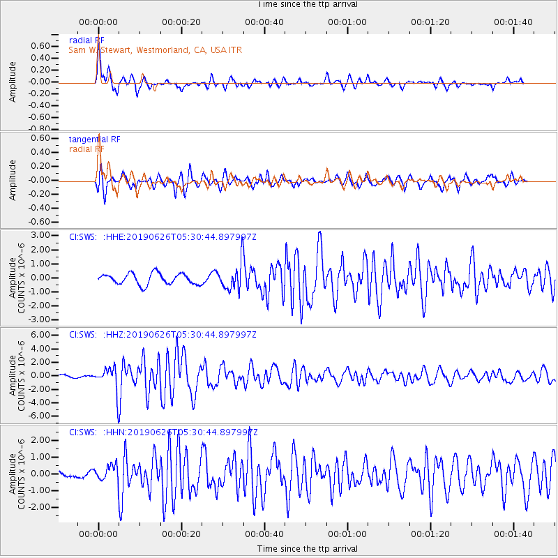
Signal To Noise
| Channel | StoN | STA | LTA |
| CI:SWS: :HHZ:20190626T05:30:44.897997Z | 8.959644 | 1.9841489E-6 | 2.2145399E-7 |
| CI:SWS: :HHN:20190626T05:30:44.897997Z | 2.1248875 | 4.966923E-7 | 2.337499E-7 |
| CI:SWS: :HHE:20190626T05:30:44.897997Z | 2.595004 | 1.002937E-6 | 3.864876E-7 |
| Arrivals |
| Ps | 2.3 SECOND |
| PpPs | 7.8 SECOND |
| PsPs/PpSs | 10 SECOND |


