You are here: Home > Network List > TA - USArray Transportable Network (new EarthScope stations) Stations List
> Station A19A Klindworth Farms, Hogeland, MT, USA > Earthquake Result Viewer
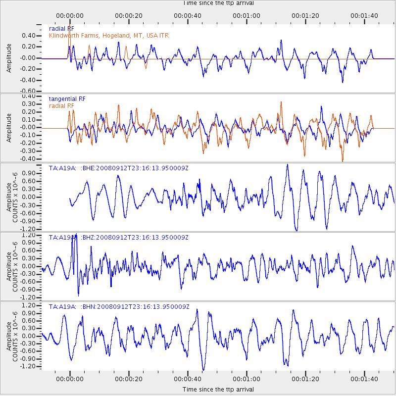
A19A Klindworth Farms, Hogeland, MT, USA - Earthquake Result Viewer
*The percent match for this event was below the threshold and hence no stack was calculated.
| Earthquake location: |
Komandorskiye Ostrova Region |
| Earthquake latitude/longitude: |
56.3/164.1 |
| Earthquake time(UTC): |
2008/09/12 (256) 23:07:50 GMT |
| Earthquake Depth: |
9.3 km |
| Earthquake Magnitude: |
5.5 MB, 5.7 MS, 5.9 MW, 5.9 MW |
| Earthquake Catalog/Contributor: |
WHDF/NEIC |
|
| Network: |
TA USArray Transportable Network (new EarthScope stations) |
| Station: |
A19A Klindworth Farms, Hogeland, MT, USA |
| Lat/Lon: |
48.93 N/108.74 W |
| Elevation: |
971 m |
|
| Distance: |
50.0 deg |
| Az: |
59.249 deg |
| Baz: |
313.426 deg |
| Ray Param: |
$rayparam |
*The percent match for this event was below the threshold and hence was not used in the summary stack. |
|
| Radial Match: |
50.37585 % |
| Radial Bump: |
382 |
| Transverse Match: |
38.55217 % |
| Transverse Bump: |
313 |
| SOD ConfigId: |
2560 |
| Insert Time: |
2010-03-07 00:46:43.936 +0000 |
| GWidth: |
2.5 |
| Max Bumps: |
400 |
| Tol: |
0.001 |
|
Signal To Noise
| Channel | StoN | STA | LTA |
| TA:A19A: :BHZ:20080912T23:16:13.950009Z | 4.2739654 | 6.6828545E-7 | 1.5636193E-7 |
| TA:A19A: :BHN:20080912T23:16:13.950009Z | 1.8337601 | 5.3269656E-7 | 2.904941E-7 |
| TA:A19A: :BHE:20080912T23:16:13.950009Z | 0.48162392 | 1.9356109E-7 | 4.018926E-7 |
| Arrivals |
| Ps | |
| PpPs | |
| PsPs/PpSs | |


