You are here: Home > Network List > TA - USArray Transportable Network (new EarthScope stations) Stations List
> Station A19A Klindworth Farms, Hogeland, MT, USA > Earthquake Result Viewer
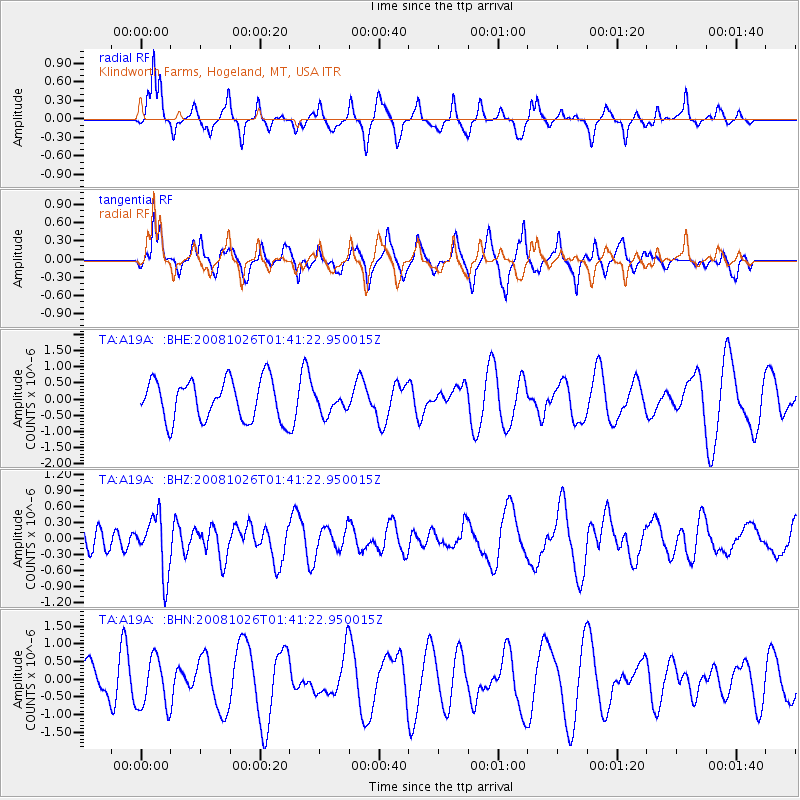
A19A Klindworth Farms, Hogeland, MT, USA - Earthquake Result Viewer
*The percent match for this event was below the threshold and hence no stack was calculated.
| Earthquake location: |
Hindu Kush Region, Afghanistan |
| Earthquake latitude/longitude: |
36.5/70.7 |
| Earthquake time(UTC): |
2008/10/26 (300) 01:28:56 GMT |
| Earthquake Depth: |
210 km |
| Earthquake Magnitude: |
5.5 MB, 5.7 MW, 5.7 MW |
| Earthquake Catalog/Contributor: |
WHDF/NEIC |
|
| Network: |
TA USArray Transportable Network (new EarthScope stations) |
| Station: |
A19A Klindworth Farms, Hogeland, MT, USA |
| Lat/Lon: |
48.93 N/108.74 W |
| Elevation: |
971 m |
|
| Distance: |
95.0 deg |
| Az: |
359.62 deg |
| Baz: |
0.464 deg |
| Ray Param: |
$rayparam |
*The percent match for this event was below the threshold and hence was not used in the summary stack. |
|
| Radial Match: |
51.123928 % |
| Radial Bump: |
300 |
| Transverse Match: |
63.814835 % |
| Transverse Bump: |
355 |
| SOD ConfigId: |
2560 |
| Insert Time: |
2010-03-07 00:46:49.720 +0000 |
| GWidth: |
2.5 |
| Max Bumps: |
400 |
| Tol: |
0.001 |
|
Signal To Noise
| Channel | StoN | STA | LTA |
| TA:A19A: :BHZ:20081026T01:41:22.950015Z | 2.0886447 | 5.3818343E-7 | 2.5767113E-7 |
| TA:A19A: :BHN:20081026T01:41:22.950015Z | 1.7973456 | 7.109636E-7 | 3.9556312E-7 |
| TA:A19A: :BHE:20081026T01:41:22.950015Z | 0.5329082 | 3.3261352E-7 | 6.2414784E-7 |
| Arrivals |
| Ps | |
| PpPs | |
| PsPs/PpSs | |


