You are here: Home > Network List > N4 - Central and EAstern US Network Stations List
> Station I45A Fountain, MI, USA > Earthquake Result Viewer
I45A Fountain, MI, USA - Earthquake Result Viewer
| Earthquake location: |
Panama-Costa Rica Border Region |
| Earthquake latitude/longitude: |
8.4/-82.8 |
| Earthquake time(UTC): |
2019/06/26 (177) 05:23:48 GMT |
| Earthquake Depth: |
10 km |
| Earthquake Magnitude: |
6.3 Mww |
| Earthquake Catalog/Contributor: |
NEIC PDE/us |
|
| Network: |
N4 Central and EAstern US Network |
| Station: |
I45A Fountain, MI, USA |
| Lat/Lon: |
44.04 N/86.23 W |
| Elevation: |
215 m |
|
| Distance: |
35.6 deg |
| Az: |
355.726 deg |
| Baz: |
174.132 deg |
| Ray Param: |
0.07714007 |
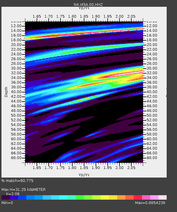
| Estimated Moho Depth: |
31.25 km |
| Estimated Crust Vp/Vs: |
2.09 |
| Assumed Crust Vp: |
6.53 km/s |
| Estimated Crust Vs: |
3.125 km/s |
| Estimated Crust Poisson's Ratio: |
0.35 |
|
| Radial Match: |
90.775 % |
| Radial Bump: |
380 |
| Transverse Match: |
65.76251 % |
| Transverse Bump: |
400 |
| SOD ConfigId: |
18369291 |
| Insert Time: |
2019-07-10 05:31:58.978 +0000 |
| GWidth: |
2.5 |
| Max Bumps: |
400 |
| Tol: |
0.001 |
|

Signal To Noise
| Channel | StoN | STA | LTA |
| N4:I45A:00:HHZ:20190626T05:30:15.508013Z | 3.105716 | 6.1511764E-7 | 1.9805985E-7 |
| N4:I45A:00:HH1:20190626T05:30:15.508013Z | 2.2262287 | 5.8442504E-7 | 2.6251797E-7 |
| N4:I45A:00:HH2:20190626T05:30:15.508013Z | 1.4700869 | 4.1221446E-7 | 2.804014E-7 |
| Arrivals |
| Ps | 5.6 SECOND |
| PpPs | 14 SECOND |
| PsPs/PpSs | 19 SECOND |


