You are here: Home > Network List > TA - USArray Transportable Network (new EarthScope stations) Stations List
> Station B19A Brinkman Farms, Chinook, MT, USA > Earthquake Result Viewer
B19A Brinkman Farms, Chinook, MT, USA - Earthquake Result Viewer
| Earthquake location: |
North Of Honduras |
| Earthquake latitude/longitude: |
16.7/-86.2 |
| Earthquake time(UTC): |
2009/05/28 (148) 08:24:45 GMT |
| Earthquake Depth: |
10 km |
| Earthquake Magnitude: |
6.7 MB, 7.2 MS, 7.3 MW, 7.3 MW |
| Earthquake Catalog/Contributor: |
WHDF/NEIC |
|
| Network: |
TA USArray Transportable Network (new EarthScope stations) |
| Station: |
B19A Brinkman Farms, Chinook, MT, USA |
| Lat/Lon: |
48.46 N/108.94 W |
| Elevation: |
803 m |
|
| Distance: |
36.7 deg |
| Az: |
334.526 deg |
| Baz: |
141.749 deg |
| Ray Param: |
0.07653968 |
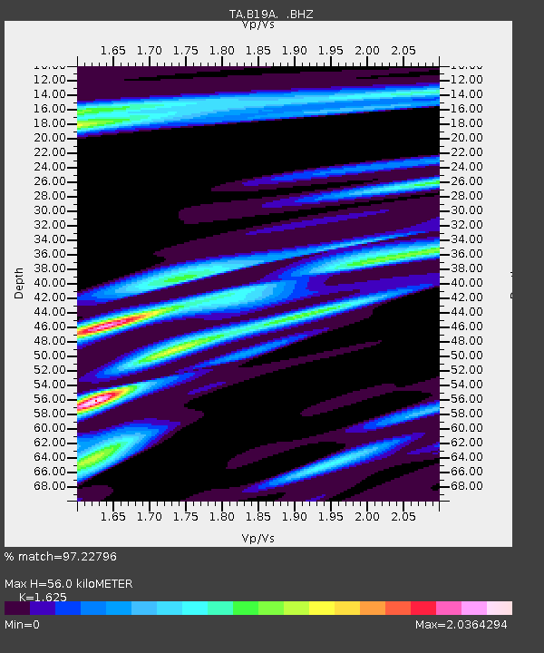
| Estimated Moho Depth: |
56.0 km |
| Estimated Crust Vp/Vs: |
1.62 |
| Assumed Crust Vp: |
6.438 km/s |
| Estimated Crust Vs: |
3.962 km/s |
| Estimated Crust Poisson's Ratio: |
0.20 |
|
| Radial Match: |
97.22796 % |
| Radial Bump: |
321 |
| Transverse Match: |
87.6436 % |
| Transverse Bump: |
400 |
| SOD ConfigId: |
2648 |
| Insert Time: |
2010-03-07 00:47:29.589 +0000 |
| GWidth: |
2.5 |
| Max Bumps: |
400 |
| Tol: |
0.001 |
|

Signal To Noise
| Channel | StoN | STA | LTA |
| TA:B19A: :BHZ:20090528T08:31:21.275007Z | 9.694985 | 1.0615098E-6 | 1.094906E-7 |
| TA:B19A: :BHN:20090528T08:31:21.275007Z | 3.2985182 | 4.4719766E-7 | 1.3557532E-7 |
| TA:B19A: :BHE:20090528T08:31:21.275007Z | 1.7096868 | 4.4685518E-7 | 2.613667E-7 |
| Arrivals |
| Ps | 5.9 SECOND |
| PpPs | 21 SECOND |
| PsPs/PpSs | 27 SECOND |


