You are here: Home > Network List > TA - USArray Transportable Network (new EarthScope stations) Stations List
> Station B19A Brinkman Farms, Chinook, MT, USA > Earthquake Result Viewer
B19A Brinkman Farms, Chinook, MT, USA - Earthquake Result Viewer

| Earthquake location: |
Honduras |
| Earthquake latitude/longitude: |
15.8/-86.9 |
| Earthquake time(UTC): |
2009/06/08 (159) 05:13:14 GMT |
| Earthquake Depth: |
10 km |
| Earthquake Magnitude: |
5.5 MB, 4.9 MS, 5.4 MW, 5.4 MW |
| Earthquake Catalog/Contributor: |
WHDF/NEIC |
|
| Network: |
TA USArray Transportable Network (new EarthScope stations) |
| Station: |
B19A Brinkman Farms, Chinook, MT, USA |
| Lat/Lon: |
48.46 N/108.94 W |
| Elevation: |
803 m |
|
| Distance: |
37.3 deg |
| Az: |
335.598 deg |
| Baz: |
143.31 deg |
| Ray Param: |
0.07622329 |
| Estimated Moho Depth: |
44.25 km |
| Estimated Crust Vp/Vs: |
1.80 |
| Assumed Crust Vp: |
6.438 km/s |
| Estimated Crust Vs: |
3.581 km/s |
| Estimated Crust Poisson's Ratio: |
0.28 |
|
| Radial Match: |
81.619995 % |
| Radial Bump: |
327 |
| Transverse Match: |
50.923958 % |
| Transverse Bump: |
400 |
| SOD ConfigId: |
2648 |
| Insert Time: |
2010-03-07 00:47:41.786 +0000 |
| GWidth: |
2.5 |
| Max Bumps: |
400 |
| Tol: |
0.001 |
|
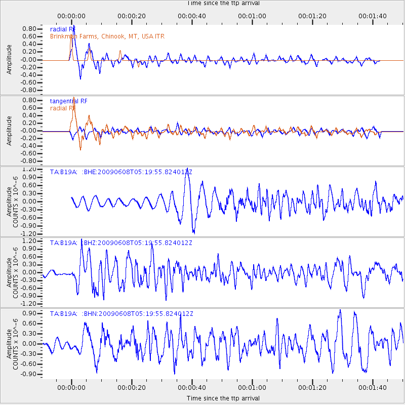
Signal To Noise
| Channel | StoN | STA | LTA |
| TA:B19A: :BHZ:20090608T05:19:55.824012Z | 5.1546044 | 4.8613157E-7 | 9.431016E-8 |
| TA:B19A: :BHN:20090608T05:19:55.824012Z | 1.7664534 | 2.677607E-7 | 1.5158096E-7 |
| TA:B19A: :BHE:20090608T05:19:55.824012Z | 1.8356897 | 2.4941923E-7 | 1.3587221E-7 |
| Arrivals |
| Ps | 5.9 SECOND |
| PpPs | 18 SECOND |
| PsPs/PpSs | 24 SECOND |


