You are here: Home > Network List > O2 - Oklahoma Consolidated Temporary Seismic Networks Stations List
> Station PW15 Ralston, Oklahoma, USA > Earthquake Result Viewer
PW15 Ralston, Oklahoma, USA - Earthquake Result Viewer
| Earthquake location: |
Panama-Costa Rica Border Region |
| Earthquake latitude/longitude: |
8.4/-82.8 |
| Earthquake time(UTC): |
2019/06/26 (177) 05:23:48 GMT |
| Earthquake Depth: |
10 km |
| Earthquake Magnitude: |
6.3 Mww |
| Earthquake Catalog/Contributor: |
NEIC PDE/us |
|
| Network: |
O2 Oklahoma Consolidated Temporary Seismic Networks |
| Station: |
PW15 Ralston, Oklahoma, USA |
| Lat/Lon: |
36.47 N/97.01 W |
| Elevation: |
270 m |
|
| Distance: |
30.8 deg |
| Az: |
337.216 deg |
| Baz: |
151.621 deg |
| Ray Param: |
0.07924561 |
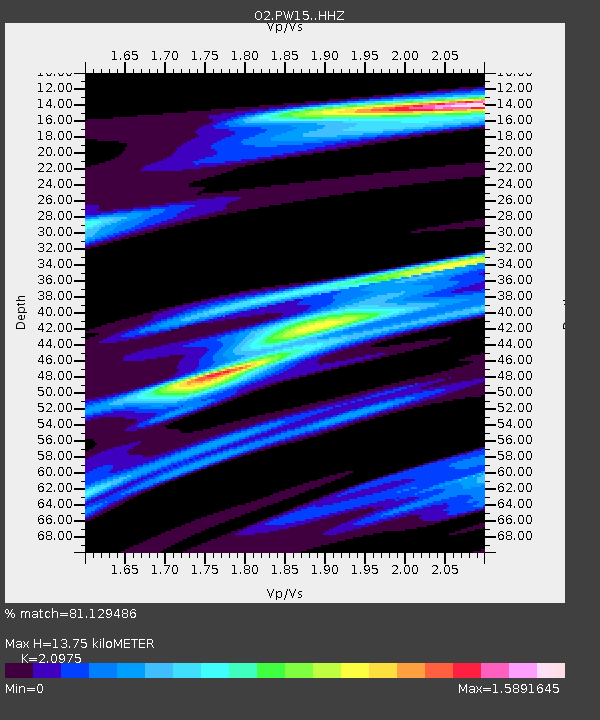
| Estimated Moho Depth: |
13.75 km |
| Estimated Crust Vp/Vs: |
2.10 |
| Assumed Crust Vp: |
6.483 km/s |
| Estimated Crust Vs: |
3.091 km/s |
| Estimated Crust Poisson's Ratio: |
0.35 |
|
| Radial Match: |
81.129486 % |
| Radial Bump: |
400 |
| Transverse Match: |
68.69771 % |
| Transverse Bump: |
400 |
| SOD ConfigId: |
18369291 |
| Insert Time: |
2019-07-10 05:33:28.115 +0000 |
| GWidth: |
2.5 |
| Max Bumps: |
400 |
| Tol: |
0.001 |
|

Signal To Noise
| Channel | StoN | STA | LTA |
| O2:PW15: :HHZ:20190626T05:29:33.53499Z | 7.125799 | 1.1379341E-6 | 1.5969214E-7 |
| O2:PW15: :HHN:20190626T05:29:33.53499Z | 4.4043074 | 7.606511E-7 | 1.7270617E-7 |
| O2:PW15: :HHE:20190626T05:29:33.53499Z | 1.5540395 | 4.5319575E-7 | 2.9162436E-7 |
| Arrivals |
| Ps | 2.5 SECOND |
| PpPs | 6.1 SECOND |
| PsPs/PpSs | 8.6 SECOND |


